2010 was a quite a weather anomaly in Florida. Here in the Tampa Bay area, the year started with the 2nd coldest winter on record, and we actually had snow stick along the I-4 corridor. Waking up to see single digit temperatures in North Florida, and then seeing an afternoon high of 42 in Miami was quite a sight. We had some explosive severe storms in the late spring, followed by the hottest summer on record. The fall was quiet as usual and we look forward to the winter cold fronts.
New Upgrades for the 2010 Season
One of the things I noticed during the 2009 season was that my equipment was not really up to snuff, so I needed to upgrade things if I wanted to move forward as a chaser. The first big upgrade was an HD video camera. I broke the first camcorder, so I got an upgrade of an upgrade, and now have the ability to shoot in full 1080p HD. The next big upgrade was the iPhone, as I now have access to radar and internet on the go. You’d be surprised how big of a difference that makes. The final, most significant upgrade was the Nikon D3000 SLR camera, so I now am able to take awesome pictures of storms, and still have the waterproof camera if I need it.
Winter: January – February – March, 2010
Cold was the name of the game this past winter. Unfortunately, the weather was so cold it made formation of severe thunderstorms impossible. El Nino years in Florida are usually good for tornados, but the cold prevented any convection. The only tornado that formed in this time frame was the March 11 Haines City tornado.
One of the winter highlights in central Florida was the January snow. Pretty much all of northern Florida had snow stick for at least a little bit. Orlando was the furthest south that snow was reported to have accumulated (mainly just a dusting). Snowflakes were reported as far south as Naples on the west coast and Kendall (a suburb south and west of Miami) on the east coast. I thought about chasing it, but the thought of Florida drivers driving in snow was a turn off. The cold sank far enough south to freeze a canal in the Everglades.
The only severe weather occured on February 5th, when a strong cold front came through. I saw a rotating wall cloud go right overhead when I was at Publix, and the storm had a tornado warning on it by the time I got home. Unfortunately the cell was moving NE at 55-60 kts, so it would have been impossible to catch. Tornado warnings popped up all over central Florida, but no twisters were confirmed.
The January 9th Florida Snow
I awoke on January 9th to gray skies and rain. A cold front had come through the previous night, and when I stepped outside it felt more like January in New England than January in Florida, as it had that feeling of snow in the air even though it was raining. Albert Whitted was reporting a temperature of 33 degrees, with a forecast high of 41.
After breakfast, I made a run to the supermarket. Sleet was hitting the windshield both to and from the supermarket.
I looked at the radar when I got home. The rain/snow line was pretty much draped right across Interstate 4. I thought about trying to drive north to find snow, but the thought of Floridians driving in the snow turned be off of that.
When I got home, I turned on the Weather Channel. It was very strange looking at the scroll bar at the bottom with the current conditions on it. Watching it scroll across and seeing “Atlanta: Partly Cloudy, 15°F. Jacksonville: Cloudy, 26°F. Tampa: Wintry Mix, 33°F. Orlando: Light Snow, 30°F.”
As the day went on, the reports came in. On the west coast, flakes were reported as far south as Naples, while on the east coast, snow was reported as far south as Kendall, a suburb to the south and west of Miami. The temperature in St. Petersburg topped out at 36 degrees, the coldest day I’ve seen in the five-plus years I’ve lived here.
Deadly Yazoo City Storms Bring Damaging Microbursts to Tampa Bay
A front associated with the system that spawned the deadly Yazoo City, MS tornadoes, came tearing through Florida on April 25th, bringing damaging winds, severe weather, and numerous unconfirmed tornadoes to the Bay area.
I intercepted the first line of storms as they came ashore at St. Pete Beach around 7:20 PM. The line had petered out quite a bit, but still brought a Severe Thunderstorm Warning and winds gusting in the 35-45 mph range.
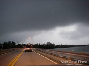
At 11 PM, there was a steady lightning and thunder to the northwest, and I knew that a second, much morepowerful line of storms was on its way. A Tornado Watch had been issued until midnight. As the line approached the coast, it bowed out and exploded. An urgent Severe Thunderstorm Warning was issued around 12:30 AM.
At 12:40, we got hit with the microburst, just a wall of rain and wind. Winds were easily 55-65 kts, gusting 75-85. I thought my downstairs windows had blown out when I heard a huge crash, but it ended up being a 20-foot tree limb that fell right next to the house!
The microburst left heavy damage in south St. Pete, with trees down all over the place. Numerous houses were damaged, and some were even destroyed. The storm was still going the next morning, with Tornado Warnings up for Fort Lauderdale and West Palm Beach. A peak gust of 77 mph was measured at Key Biscayne around 8 AM.
So What’s the Difference Between a Tornado and a Microburst
So what’s the difference between a microburst and a tornado? The answer’s pretty simple: Microbursts are straight-line winds, while tornados are rotational winds. Determining whether a storm contained a microburst or a tornado is a little difficult, as the only way to do so is to analyze the damage.
At the ground level, a tornado contains strong updrafts, which tends to rip things out of the ground and throw them in all different directions, while a microburst is associated with a strong downdraft, which tends to just blow things over. The damage path from a tornado often tends to be much more erratic than the damage path from a microburst.
Summer Season Opens with a Bang in Manatee County
Parameters on the morning of May 28th looked excellent for storms, so in the afternoon I was out chasing. I got off Interstate 75 in the town of Parrish and headed east on SR-62 for about 30 miles. The storm grew continuously more impressive and more beautiful as I got closer. As I approached the western flank of the storm, the NOAA Weather Radio had put out massive flood warnings with the storm, so I opted not to drive into the storm. I parked the truck at the intersection of SR-62 and CR-39 near the small town of Duette and started to take photographs, just as the storm started to fall apart. It wasn’t quite an ideal spot, with a tree line on the south side of 62. As I was watching the storm, it recoiled and re-fired just to the south. A quick check of the GPS showed no southbound roads nearby, and my iPhone was out of data network range.
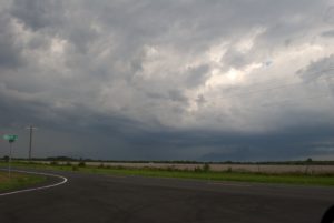 Rotating Thunderstorm near Duette, FL on May 28, 2010
I turned the truck around and headed back west on SR-62. About a mile down the road there was a small street called Bunker Hill Loop that had a wide open view to the south. I pulled onto Bunker Hill Loop, turned around, and parked right by the intersection, and started shooting. The photos came out incredible! I needed to get south. Unfortunately I had to backtrack 17 miles to get to the nearest southbound road and by the time I got there the storm had dissipated.
Spectacular Lightning Display Caps Off the June 3rd Tampa Trifecta
At about 2:30 PM, I looked at the radar, and found most of I-4 between Tampa and Orlando was under various Severe Thunderstorm Warnings. I set my eyes on one of those severe- warned cells was in the Brandon area, tracking north/northeast towards the interstate. By the time I got onto I-4, a new Severe Thunderstorm Warning was issued on a huge cell just to the north. The storm had a well-defined mesocyclone on it.
I got off of I-4 at Exit 10 and headed north on Mango Rd, where I picked up US-301. I was able to track along right on the southeastern flank of the impressive storm, but huge trees on the side of the road prevented me from taking any good pictures. The storm was drifting slowly to the northeast, and without any eastbound roads, I soon found myself swallowed up in the edge of the rain core. Once inside the rain core, there were some very impressive lightning strikes pretty close to me, with one striking a radio tower less than a quarter- mile away. I knew I was going to have to punch the core to get back to I-75, so I turned west onto SR-54 and went for it. I did have to battle heavy wind and rain (and saw some pretty flooded yards), but all in all, it was an uneventful and successful core punch.
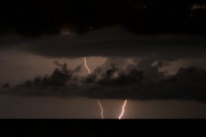
Back home, around sunset, I noticed that there were some ominous dark clouds to the west. After seeing a few faint flashes in the sky, I grabbed the camera and headed out to the beach. A line of thunderstorms was about 20 miles offshore and headed straight for us. I stood on the beach and took pictures of the storm from about 9:00-9:40 PM and got some great lightning pictures. The setup for lightning pictures could not have been any more textbook. The timing worked out great, too, as my camera ran out of batteries just as it started to rain.
Explosive Severe Storm Packs 1,100 Lightning Strikes in 15 Minutes
If you haven’t figured it out yet, that equates to 1.2 lightning strikes per second. One of the best storms of the summer through the St. Pete area on the evening of June 21st. To put the icing on the cake, too, the storm came to me, so I didn’t have to leave the house to intercept it! The storm surely made you realize why they call the area “Lightning Alley.”
The storm formed over Hillsborough County and moved west/northwest. When it emerged over the waters of Tampa Bay and collided with the afternoon sea breeze, it just exploded, growing into a monster severe thunderstorm by about 6:30 PM. A Severe Thunderstorm Warning was issued for Pinellas County shortly thereafter. The storm came ashore in St. Petersburg with full force around 6:40. At the house, winds gusted in the 45-55 mph range and rain came down so hard you could barely see.
Between 6:30 and 6:45, nearly 1,100 lightning strikes hit the Tampa Bay area, or an average of 1.2 strikes per second. The highest recorded wind gust was 70 mph at MacDill Air Force Base in Tampa. Back at the house, the lightning show was starting. The first close lightning strike hit less than 200 feet from me, and then numerous lightning strikes hit within 1/4 mile over the next 20 minutes.
Waterspouts Break Out Over West Florida Waters
Everything was in place on August 8th for some great storms to fire across the Florida peninsula. Around 4 PM, I noticed the skies to the NE were darkening, so I took a quick peek at the radar. There was a pretty nice looking line of storms headed our way, so I jumped in the truck and headed for my favorite spot at the Pinellas Point Boat Ramp. There was a Special Marine Warning up for Tampa Bay advising boaters of a significant threat of waterspouts, along with the standard gusty winds and deadly lightning. Another Special Marine Warning was issued for the coastal Gulf of Mexico waters, from the Skyway to Clearwater Beach.
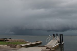
When I got to the ramp, I could see the wall of rain to the north that was slowly approaching. Just to the east of the boat ramp, the base of the clouds was starting to lower, and the whole thing was spinning. I was pretty excited at the possibility of a waterspout, but after the clouds lowered slightly, they just kept rotating and never really tightened up enough all at once to put down anything tornadic. It was agonizing watching it, but as the wall of rain approached, it slowly became clear that it just wasn’t meant to be. The pictures came out great. There was a radar- detected waterspout 3 mi NW of Indian Rocks Beach, but nothing was confirmed.
Looking Ahead to 2011
2010 is behind me. I’ve upgraded my equipment, familiarized myself with the new camera, and taken some great weather shots. Now it’s time for me to go out in 2011 and make things happen.
2011 is shaping up to be a great year. I have a couple exciting projects planned. One will based out of Key Biscayne, the edge of the Waterspout Capital of America, as I’m trying to get as many South Florida waterspouts shots as I can.
The big addition to the spring schedule is a week-long chasing trip in May to Oklahoma and Texas to document tornadoes and supercells in the heart of Tornado Alley. 2011 should be another great year in South Florida. I also now have a Twitter account set up on the website as well so you can get up-to-the-minute updates. Happy Chasing everyone!