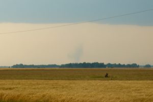
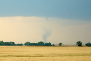
On May 19, 2012, I observed and photographed a landspout and two tornadoes near Harper, Kansas. The term “landspout” is not used very often so I will attempt to explain what it means and how it differs from a tornado.
Tornadoes
Most tornadoes are driven by a mesocyclone in a thunderstorm. The mesocyclone is an area of rotating rising air around a vertical axis in a thunderstorm. They usually range from 2 to 10 miles in diameter and are most commonly associated with vigorous rotating updrafts in a supercell thunderstorm. When a tornado forms from a mesocyclone, you will usually first see a funnel cloud and then the tornado will grow downward from the bottom of the cloud until it touches down. Landspouts, which are tornadoes that are not associated with a storm’s mesocyclone, are much easier to understand if we can understand waterspouts first.
Waterspouts
You probably know that a waterspout is just a tornado over water. They are observed all over the world, and can happen anywhere. What you probably don’t know is that there are two types of waterspouts: tornadic waterspouts and fair-weather waterspouts. Tornadic waterspouts are simply waterspouts that are driven by a storm’s mesocyclone, and are no different than tornadoes you see tearing across the Great Plains. They can be very destructive, but thankfully are fairly rare in coastal areas.
What we are interested here is the fair-weather waterspout (sometimes called a non-tornadic waterspout, but I don’t like that term). Fair weather waterspouts are tornadoes over water that are not associated with or driven by a storm’s mesocyclone. Instead, they are driven by circulations at the surface, which can be from swirling winds at the surface, air blowing around an island, circulations from outflow boundaries of nearby storms, or anything else like that.
If you watch a fair-weather waterspout form, it will begin at the surface and grow upward toward the cloud base. Sometimes they will last long enough to connect with the base of the cloud, and sometimes they won’t. Since the circulation is surface based, these waterspouts don’t have the persistent rotation of a mesocyclone driving them, so they are usually weak and short-lived, but still can do damage. They will often have a smooth, tubular shape instead of the more classic vortex shape many tornadoes have. Don’t be confused though, many tornadoes also take this shape, and can sometimes appear to start at the surface and grow upward as well.
How Do Landspouts Tie Into All This?
Landspouts tie into this very simply. A landspout is just a fair-weather waterspout that occurs over land. It can be difficult to determine whether you are looking at a landspout or tornado without other data from the storm. Consider the following two pictures I took on May 19, 2012 near Harper, Kansas. One is a tornado, and the other is a landspout. Do you know which is which?

Landspout
 Tornado
The first photo is the landspout and the second photo is the tornado. In the first one you can see a weak, surface-based circulation with no connection to the cloud. On the other hand, the second photo has a funnel that connects to a debris cloud on the ground (not a visible connection, but you can connect the dots).
The landspout here was on the ground for less than a minute and appeared to be weak and unorganized. The tornado, on the other hand, had much more persistent rotation and upward motion and was on the ground for 3 to 5 minutes before dissipating. A look back at the storm-relative velocities on radar when I got home confirmed that the landspout was away from the mesocyclone, while the tornado was right underneath the mesocyclone. In this instance, there was no sure-fire way to know whether you are looking at a tornado or landspout other than to have radar confirmation. Gustnadoes and dust devils are also cousins of the landspout, but I’ll go into those details at some later point. I hope you now know a little more about landspouts, and if you have any questions, don’t hesitate to ask.