Large Scale Setup/Discussion
A weak wave of energy is currently crossing Colorado’s Rocky Mountains and is forecast to undergo “lee cyclogenesis” (it’s actually more of a lee intensification) as it ejects off the Front Range and into the Great Plains on Thursday, ahead of a much more powerful upper level storm system moving into the southwestern US. If you still have my Winter Storm notes, this falls into the “Overrunning” category of winter storm. Unseasonably warm temperatures and high dewpoints currently sit across the Central/Southern Plains and Ohio Valley. Expect this cyclone to intensify as it travels through this rich fuel supply and head towards New England.
Adding to the complexity of this forecast is the presence of energy in the subtropical jet (or southern branch of the jet), which is forecast to be sitting along the northern Gulf Coast by 12 UTC/7 AM EST on Friday. As that wave of energy moves across Gulf Coast/Northern Florida, both GFS and ECMWF are forecasting development of a surface cyclone off the coast of the Carolinas, giving you a Miller A Type system, which will be very rich with Gulf of Mexico and Subtropical Atlantic moisture. The surface cyclone from the Miller A system will then merge with the surface cyclone from the Overrunning system coming out of the Ohio Valley, and be driven by the strong upper-level cyclone from the Overrunning system. Coupled with the very high amount of moisture both systems have access to, this leaves the probability of all hell being unleashed somewhere in the northeast quite high (the figures below are from GFS).
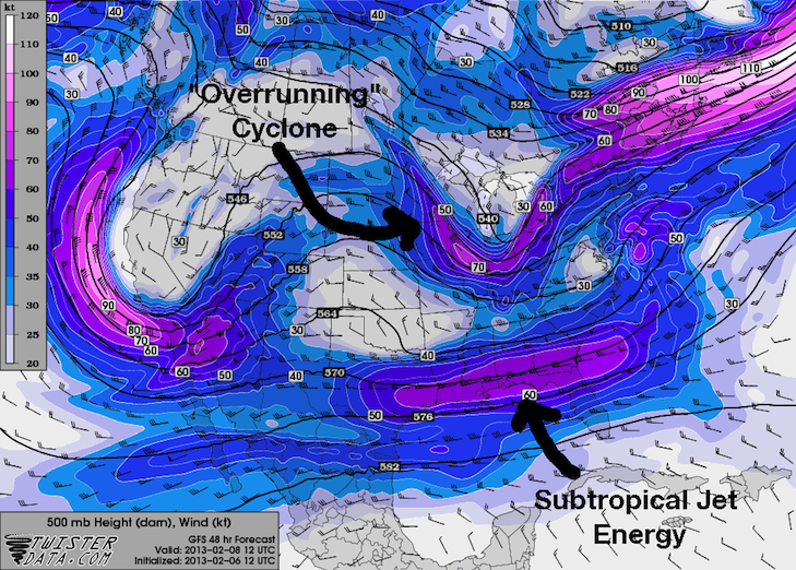
500 mb Wind and Heights

Impacts to the Northeast
Let’s switch gears and take a look at the European Model (ECMWF) for Saturday at 12 UTC (7 AM EST).
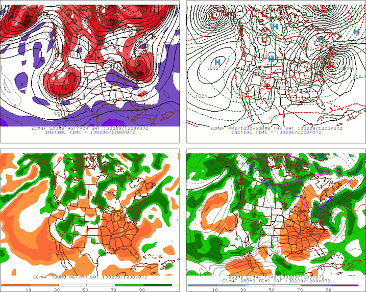
You can probably see the combined surface low (upper right panel) looks pretty impressive. Both GFS and ECMWF have it at 992 mb, which is a pretty healthy low, but not crazy. To put it into perspective, your run-of-the-mill Category 1 Hurricanes are usually in the 970-980 mb range. Two surface highs of 1032 mb are forecast to sit over central Quebec and southern Michigan. This 40 mb difference will lead to a sharp pressure gradient, so expect lots of wind. GFS is showing 55-65 knot winds over Cape Cod at 12 UTC/7 AM EST Saturday. Depending on where exactly the surface cyclone passes, winds will be out of either the northeast, north, or northwest. The upper level cyclone (upper left panel) should be healthy as well.
The panels that have me the most concerned are the two bottom panels, which show relative humidity at 700 mb (left) and 850 mb (right). Both levels are absolutely loaded with moisture, so if temperatures and lift (which will be discussed next) are in the right place, this storm could be crippling.
Temperatures, Precipitation, and Accumulation
Before we even think about precipitation type and accumulations, we need to look at temperatures to make sure it is cold enough to support snow. The easiest way is to take a look at a couple of forecast soundings.
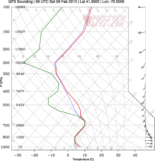
00Z Saturday/7 PM EST Friday
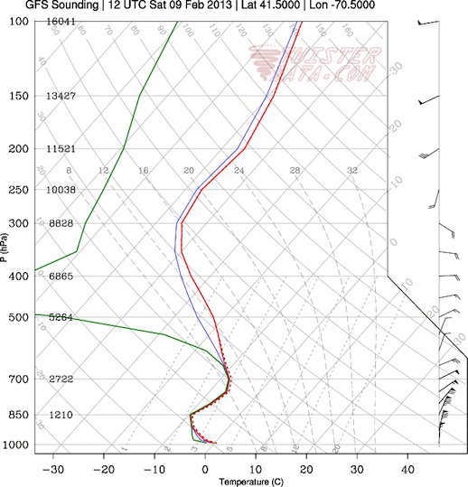
12Z/7 AM EST Saturday
There is a thin warm layer at the surface on Friday evening…don’t let that fool you. Temperatures will cool in the evening with the daytime heating cycle, and will then cool even further with the passage of a cold front overnight Friday into Saturday. Depending on exactly when precipitation starts, it may start as rain/sleet/freezing rain, but I would expect it to change over to snow sometime before midnight EST. It is important to note that the Friday evening sounding is prior to the passage of the cold front, while Saturday morning is after the cold front passes. If you’re wondering how I know this, look at the wind profile on the right hand side of the sounding (below 700 mb). On Friday evening, the wind direction veers (turns clockwise) with height, which indicates warm temperature advection (don’t be fooled…this is a very common feature ahead of cold fronts). On Saturday morning, you have the exact opposite. The wind direction backs (turns counterclockwise) with height, which is indicative of cold temperature advection.
The Saturday morning sounding is a textbook winter weather sounding (don’t hesitate to compare these to the Blizzard of ’05 soundings in my notes). The whole profile is below freezing, so I expect precipitation to fall as snow. If you go back to my notes, you will remember something called the “Snow Growth Zone,” which can be found between -18°C and -12°C. On Saturday morning, this zone can be found just above 700 mb. If lift can be maximized just below the “Snow Growth Zone,” the probability of being absolutely dumped on goes up significantly. Don’t forget, too, that the axis of heaviest snow generally follows the track of the 700 mb low.
So let’s now take a look at lift. The GFS conveniently plots vertical velocity along with height contours at 700 mb, so let’s take a look at it.
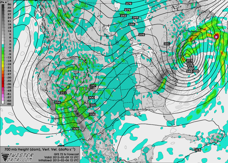
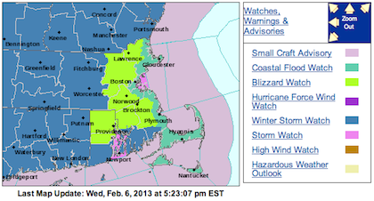
You can probably see that the 700 mb low tracks pretty much right over Cape Cod, with the area of maximum lift in the orange just southwest of the Cape. This means you’re gonna see plenty of snow. Like I mentioned in my notes, forecasting total accumulations is very difficult, so I will defer to the National Weather Service for that. They are currently (at about 5:30 PM EST) calling for 10-14 inches on the western end of Cape Cod, and for 14-18 inches on the west sides of Buzzards Bay back into Rhode Island. Current watches and warnings are as follows (the NWS just released a discussion saying that the Winter Storm Watch has been cancelled and replaced with a Blizzard Watch for the entire region, which includes Cape Cod and the Islands):
The Verdict
I would expect this to be a pretty significant storm. It certainly has the potential to rival the Blizzard of ’05, but I really don’t think it will. The low pressure systems are too close together in the vertical direction to really be able unleash their full fury. My gut is telling me you will be on the upper end of the 10-14 inch accumulation range, but things can change. The winds will be the greatest concern. I would expect to see winds close to hurricane force (if not above) for an extended period of time, which result in dangerous wind chills between 0 and 10°F. The good news, though, is that the system is moving pretty fast so it will be in and out quickly.
Originally Written Wednesday, February 6, 2013 at 5:00 PM CST /6:00 PM EST/