A very powerful arctic cold front will be impacting much of the lower 48 this week, bringing the coldest air in over a year to much of the plains. Several waves of jet stream energy will come out across Oklahoma between Thursday and Monday, resulting in all sorts of winter precipitation to the Sooner State.
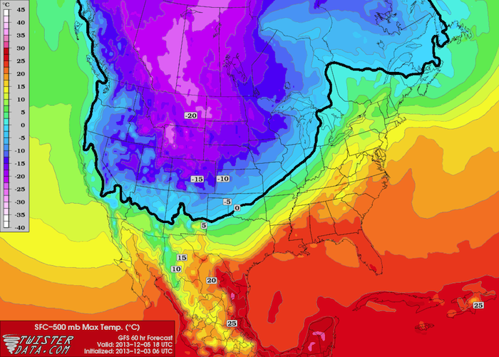
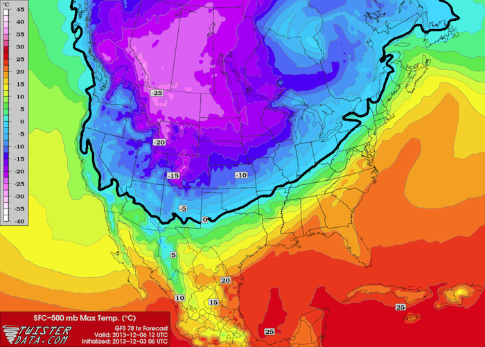
Once again, predicting exactly what type and how much precipitation at any given location. Things should become a lot clearer in the next couple days, especially after the front comes through overnight tonight. Right now, it looks like the snow/winter mix line will initially set up shop just south and east of Interstate 44 and will slide southeast as colder air filters into the mid-levels behind the front. The graphics below indicate the maximum temperature in the cloud and precipitation layer, and the snow/winter mix line will be near the 0°C line, which is highlighted in thick black.

Sfc-500 mb Max Temp (°C), Thurs at 12 Noon CST

Sfc-500 mb Max Temp (°C), Fri at 6 AM CST
For Oklahoma, any precipitation that falls north and west of that 0°C line will fall as snow, and anything that falls south and east of that line will fall as sleet or freezing rain (and even rain in the far southeast part of the state).
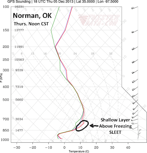
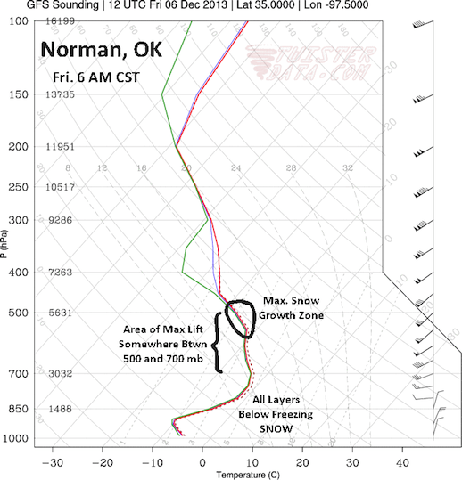
Since the snow/winter mix line will initially set up so close to the Oklahoma City area, let’s take a look at some forecast soundings for Norman, for Thursday at Noon CST (left) and Friday at 6 AM CST (right).


According to the GFS model, on Thursday afternoon, a thin layer of above-freezing temperatures will be present between about 850 and 750 mb. Any snow that passes through this layer will melt before refreezing below 850 mb (about 4500 feet), resulting in sleet in the Norman area, which may start as freezing rain. That same layer will also be a lot drier than the any of the surrounding layers, which could result in some evaporation and less precipitation reaching the ground.
The changeover from sleet to snow should occur between Midnight and 3 AM CST on Friday, as the warm layer cools below freezing, and precipitation in the Norman area should be all snow by 6 AM CST Friday. Exactly how much snowfall we get is still to be determined. Models are in pretty good agreement that the maximum snow growth zone, which occurs between -20°C and -10°C, will be somewhere near 500 mb, but there is still some disagreement as to where the area of maximum lift will be. Some models match up the area of maximum lift with the maximum snow growth zone, while some place the area of maximum lift well below it. If the two areas match up, the area will see higher snowfall totals, but that remains to be seen.
Exact snowfall totals will also depend on when the changeover from the winter mix to snow occurs. More sleet and freezing rain will result in less snowfall. I will go with a slightly conservative initial guess of 1 to 4 inches of snow, depending on exactly where you are, but those numbers could easily go up. Areas of southern and southeastern Oklahoma are more likely to see an ice storm than a snow storm. Nearly all Oklahoma counties along and south/east of a line from Lawton to El Reno to Ponca City are under a Winter Storm Watch already, so stay tuned for more info. I will be back with another update later this afternoon/evening.