A pattern shift in the jet stream has let Feburary start with quite a bang after a pretty quiet January. A series of winter storms that has come through and will be coming through Oklahoma this week will be impacting parts of the east coast as well.
Tuesday, February 4th: Boston, MA and Washington, DC
The winter storm that passed through Oklahoma on Sunday is currently centered over the Tennessee valley and will be well offshore by sunrise on Tuesday, and will bring precipitations along the coast of the Mid-Atlantic and Southern New England. Areas north of the Mason-Dixon Line could see a few more inches of snow, with some isolated higher totals possible, especially along the Connecticut coast and Long Island. All precipitation will end by 11 PM EST tonight.
The second winter storm will eject over the southern plains from the Rockies tonight and will be moving rapidly to the east/northeast on Tuesday. This storm will be approaching the east coast by Wednesday morning. I’ll start by looking at the GFS model output of the big picture, and one of my favorite winter weather plots, the maximum temperature in the precipitation column (surface to 500 mb), which is a great way to help determine what type of precipitation will fall. If you are north of the thick black line (the 0°C max temp line), you will get snow. South of it, we will need to look at surface temperatures and soundings to determing the type of precipitation.
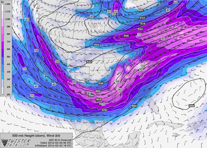
500 mb Wind/Height – Tuesday at 7 PM EST

Sfc – 500 mb Max. Temperature – Tuesday at 7 PM EST
The Boston area will not see any precipitation between about 7 PM EST Monday and 7 AM EST Wednesday. In Washington, DC, precipitation should start between 10 PM EST Tuesday and 1 AM EST Wednesday. Since we are looking at one specific location, let’s fast forward and look at a couple soundings from Washington, DC after daybreak on Wednesday. Precipitation will end in Washington by midday Wednesday
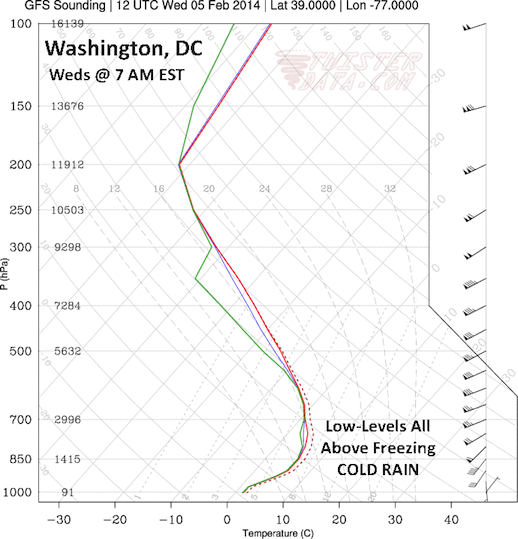
Washington, DC Forecast Sounding – 7 AM EST Wednesday
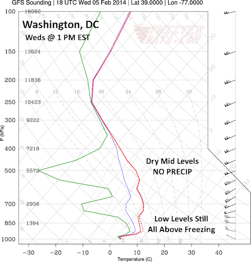
Washington, DC Forecast Sounding – 1 PM EST Wednesday
The most significant feature I notice on these soundings is that the low-level temperatures all stay above freezing, so any precipitation that falls will fall as a cold rain. However, I should note that the surface temperatures are very close to freezing, so just a few degree drop in surface temperature could result in freezing rain instead.
Thursday, February 6th: Washington, DC and Raleigh, NC
Things appear to quiet down for at least a few days beginning on Thursday. I do not anticipate any travel problems on Thursday, as skies will clear overnight Wednesday in both Washington and Raleigh, and temperatures will fall into the 20’s and 30’s. Skies will be partly cloudy by sunrise on Thursday, with high temps in the 40’s across all of North Carolina on Thursday.
Sunday, Feburary 9th: Raleigh, NC and Boston, MA
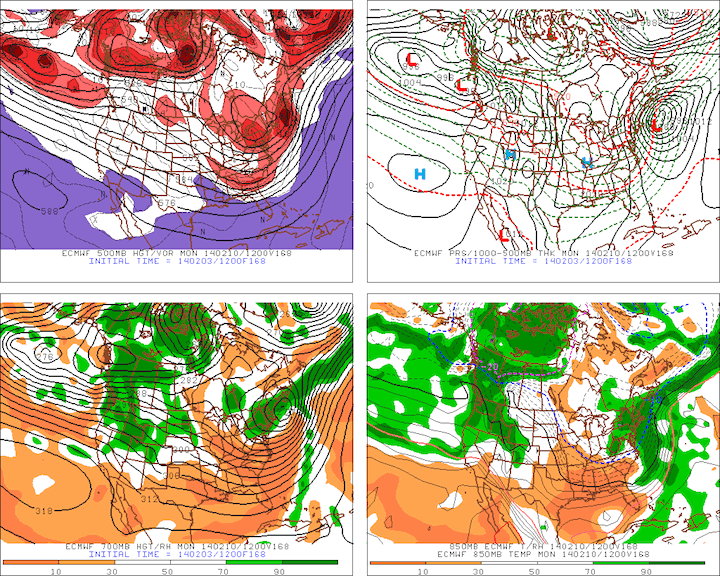
Before I even begin, I do want to point out that Sunday is still 6 days away, so confidence in this forecast is low. A powerful upper-level low is set to come off the Rockies and eject across the southern plains on Saturday, bringing more wintry precipitation to parts of Kansas, Oklahoma, and Texas. This storm is taking a much more southerly track than the previous two, which will likely allow it to tap into rich, Gulf of Mexico moisture. Models are currently showing the upper-level low centered near Dallas, TX at 7 AM EST on Sunday, and the surface low centered over Alabama. Below you will find the ECMWF model output for Sunday at 7 AM EST. Do take note that this setup is screaming “Textbook Significant Coastal Storm” at me, but it will likely not begin to impact the coast before Sunday night.

ECMWF Forecast – 7 AM EST Sunday, Feb. 9th
The nice thing about storms that track further south is that the warm sector is plenty warm, which will keep temperatures in North Carolina well above freezing on Sunday. There will likely be rain around on Sunday, but I do not anticipate wintry precipitation at this time, but be aware that things could change between now and Sunday.
Further up the coast in Boston, it will be cold, but there will not be any precipitation at all on Sunday. Models are showing the developing nor’easter starting to move up the coast on Sunday night, with precipitation moving into the Boston area between midnight and 3 AM EST on Monday. Again, I want to reiterate that this is still close to a week away and that things will change between now and them, so I will be posting further updates as I gain confidence in the forecasts. I’ll leave you with the ECMWF model forecast for 7 AM EST on Monday, Feb. 10th, which reinforces the setup screaming “Big Time Coastal Storm.”
ECMWF Forecast – 7 AM EST Monday, Feb 10th
I will be posting forecasts for Oklahoma later this week as this storm approaches.