Well, we have our first named storm of the 2014 Hurricane Season. As of this morning’s 11 AM EDT advisory from the National Hurricane Center, Arthur was centered just east of Daytona Beach, FL with maximum sustained winds of 60 mph. The storm is forecast to move up the east coast of the United States over the next few days.
So let’s have a quick look at what might be in store for Arthur. This early in the season, sea surface temperatures play a critical role in the health and lifespan of tropical cyclones since water temperatures are so cold from about Virginia northward.
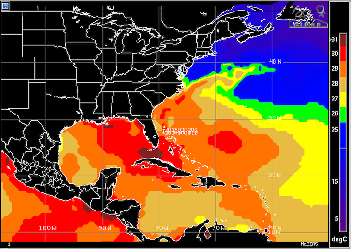
Sea Surface Temperatures – Tuesday, July 2nd
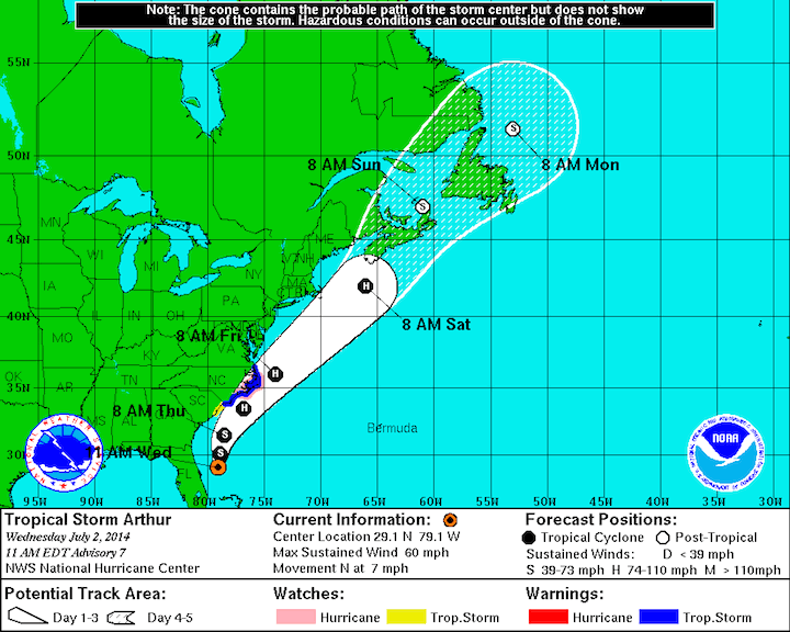
11 AM EDT Nat’l Hurricane Center Forecast
Because of the cold sea surface temperatures (the blue color on the map), ranging from about 60 to 75°F, Arthur will not hold together as a hurricane if it hugs the coast on its journey northward, and will rapidly weaken north of the Outer Banks. Remember that tropical cyclones generally require sea surface temperatures above 85°F to be able to maintain themselves or intensify.
However, if Arthur remains further offshore, it may be able to tap into the Gulf Stream (the wedge of warm sea surface temperatures extending northeast from the Outer Banks). If this happens, it has a much better chance of maintaining hurricane intensity as it progresses northward. This is why the Hurricane Center maintains Arthur as a hurricane so far north. However, a slight deviation left or right would put the storm over much colder waters. Either way this is good news for the east coast.
The other important factor to consider with any tropical cyclone is wind shear. The plots below show shear and shear tendency. There does not appear to be much by the way of significant wind shear in Arthur’s forecast path right now and the tendencies are for the shear to decrease, which would favor the storm to strengthen before it gets to the cold water.
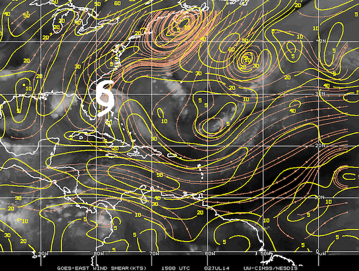 Wind Shear: Tuesday Morning, July 2nd
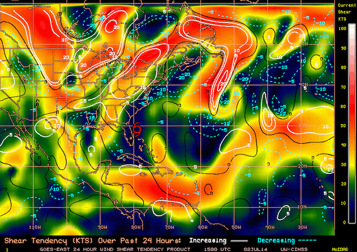
Shear Tendency: Tuesday Morning, July 2nd
I do want to note that the jet stream is forecast to be near the northeast coast of the US by the time Arthur gets up that way. There are several things that could happen as the two begin to interact. The most likely thing to happen is that Arthur will transition to extratropical and essentially become a nor’easter as it is absorbed into the jet stream. This would bring gusty winds and heavy rains to the east coast, and especially to New England. Forecast soundings from Chatham, MA are currently showing sustained winds out of the northwest at anywhere from 15 to 45 mph at Arthur’s closest pass.
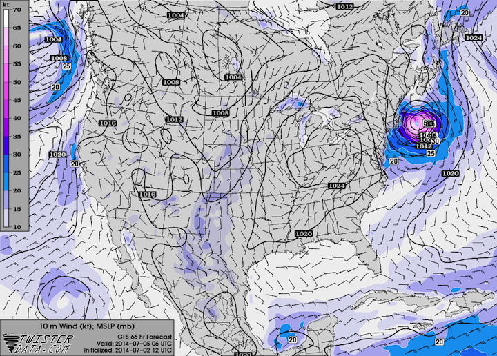
GFS Surface Wind/Pressure: Saturday at 2 AM EDT
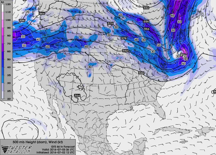
GFS 500 mb Wind/Height: Saturday at 2 AM EDT
Right now, the only area that’s really under the gun from this storm is the Outer Banks of North Carolina, which will likely see either strong tropical storm or minimum Category 1 hurricane conditions. After that, the storm will likely move offshore, but if it deviates closer to the coast, it will be over much colder waters and will have a very hard time staying together.