Today, let’s take a virtual trip south of the border to explore the more unusual side of Mexico’s geography. From the hot, dusty deserts in the north to stunning Sierra Madre Occidental and Oriental Mountains to the tropical jungles in the south, Mexico is an incredibly diverse country with so much to offer.
Similar to the United States, Mexico contains 32 states and a federal district (El Distrito Federal). The vast majority of my international adventures take me to Mexico’s Sonora and Baja California states. Mexico’s unusual shape makes it a prime location for some unexpected geography quirks that are just as fascinating as they are bizarre. Let’s go take a look.
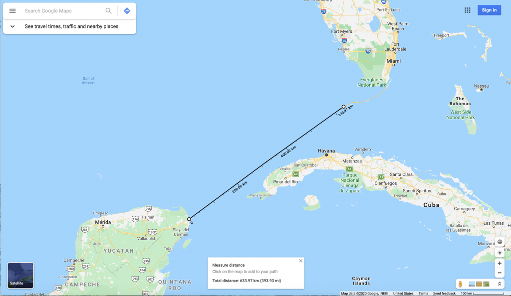
1. At its closest point, Mexico sits less than 400 miles (644 km) from Florida
As the crow flies, it’s 394 miles (634 km) from downtown Key West, Florida to downtown Cancún, Quintana Roo. To put that into perspective, it is about 350 miles (563 km) from Los Angeles to San Francisco. Every year, sailboat races run between Florida and the Yucatán peninsula.
2. Most of the country’s signature liquor is made in the Town of Tequila, Jalisco
The town, which only has about 40,000 residents, sits in the mountains of Jalisco state, about 60 km (37 mi) west-northwest of Guadalajara. The town produces about 1,000 liters of tequila every day. The liquor is distilled from the blue agave plant, which thrives in the fertile hills of west-central Mexico.
Fun Fact: The Mexican government protects the name “tequila” and heavily restricts what can be legally sold as tequila. Only liquor made from a special type of blue agave plant that is grown in a few select municipalities may be sold as tequila. Everything else must be sold as mezcal. Tequila can be legally produced throughout the entire state of Jalisco, as well as in specific municipalities in the following states:
- Guanajuato
- Michoacán
- Nayarit
- Tamaulipas
The closest tequila distillery to the United States is the Tequilera La Gonzaleña in González, Tamaulipas, which is about 350 km (220 mi) south of Brownsville, Texas. It is the only distillery in the State of Tamaulipas that can legally make tequila. Blue agave grown in that part of Tamaulipas is richer in flavor and intensity than blue agave grown in other parts of Mexico.
And speaking of Tamaulipas…
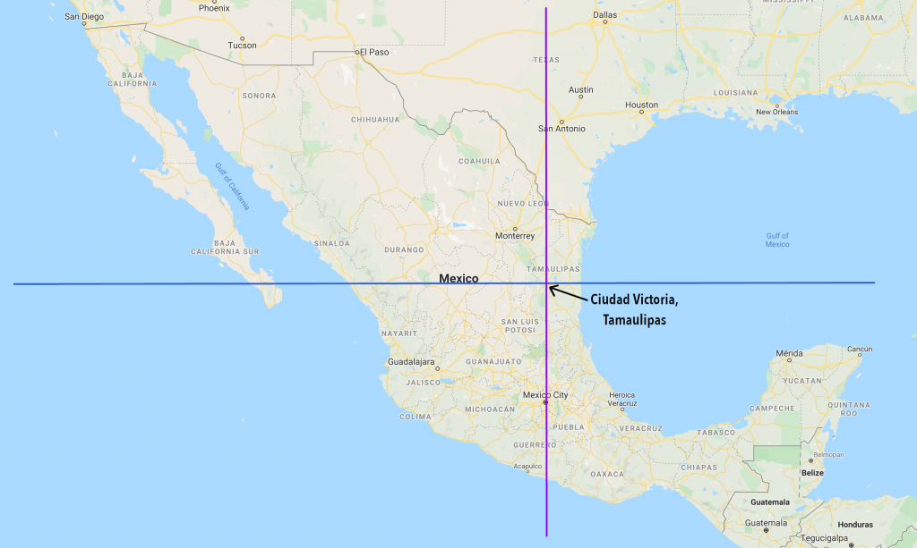
3. Tamaulipas, Mexico’s northeastern-most state, is neither the northernmost nor the easternmost state in the country
Not by a long shot. Mexico’s northernmost state is Baja California, and it’s easternmost state is Quintana Roo. In fact, if you draw a horizontal line of latitude through Ciudad Victoria, the capital of Tamaulipas, parts of 10 other states fall north of that line, and parts of 14 other states would fall east of a vertical line of longitude through the same point.
Do you feel this taking a turn towards the bizarre yet?
4. Contrary to popular belief, Cancún is further north than both Mexico City and Puerto Vallarta
Cancún sits at 21.1619°N latitude. Mexico City sits at 19.4326°N, and Puerto Vallarta sits at 20.6534°N.
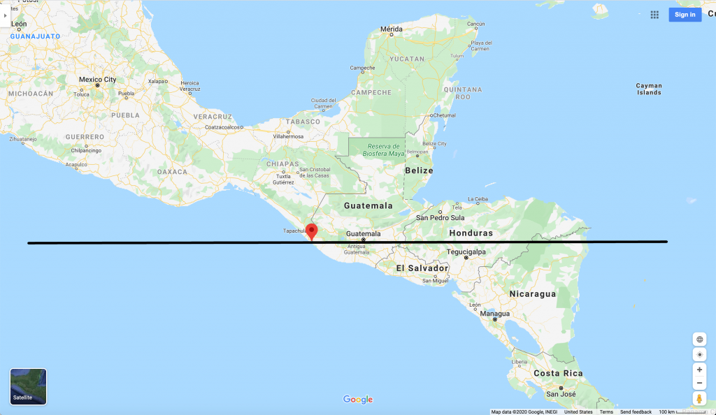
5. The southernmost town in Mexico is further south than the majority of both Guatemala and Honduras
La Libertad, Chiapas is a small town on the Suchiate River, which forms the border between Mexico and Guatemala. Most people don’t realize that the part of Central America where Guatemala, Honduras, El Salvador, and Nicaragua sit runs primarily east-west.
6. Mexico’s Copper Canyon is both longer and deeper than the Grand Canyon
However, it is important to note that Copper Canyon is actually a system of 6 canyons, and the Grand Canyon is longer than each individual canyon in Copper Canyon.
Copper Canyon (Barrancas del Cobre in Spanish), runs through the heart of the Sierra Madre Occidental mountains in the State of Chihuahua. To get there, take one of the most spectacular train rides in the world on the Ferrocarril Chihuahua al Pacífico (Chihuahua to Pacific Railroad). The park is also accessible from Federal Highway 16, which connects Chihuahua City to Hermosillo, Sonora.
| Copper Canyon | Grand Canyon | |
| Total Length | 540 km / 336 mi | 446 km / 277 mi |
| Max Depth | 1,870 m / 6,135 ft | 1,480 m / 4,856 ft |
| Max Elevation of Rim | 2,540 m / 8,333 ft | 2,760 m / 9,055 ft |
| Max Width | 4 km / 2.5 mi | 15 km / 9 mi |
If that’s not enough, Copper Canyon is also home to Mexico’s second-highest waterfall, Cascada de Basaseachi, which sits at a whopping 246 meters (807 ft) high.
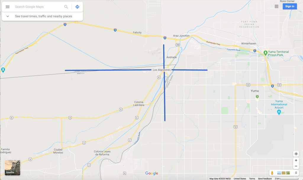
7. The border town of Los Algodones, Baja California sits just west of Yuma, Arizona. From the center of town, you can go any of the 4 cardinal directions and hit the United States.
While Los Algodones is the only place in Mexico from where you can travel any of the four cardinal directions (due north, south, east, or west) and hit the United States, it’s far from the only place where you can look south from Mexico into the United States. There are plenty of places along the Río Grande where you can do that, too.
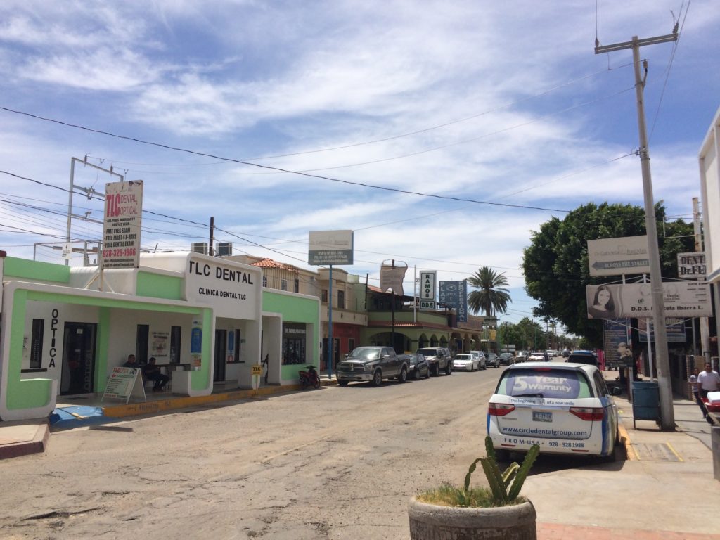
Los Algodones, which means “The Cotton Fields” in Spanish, is one of the most unique border town experiences in the world. If you visit, you can experience the following:
- Known as “Molar City”, Los Algodones has the highest concentration of dentists per capita in the world (about 600 dentists within just a few square blocks), making it a premier destination for medical tourism. It also has one of the highest concentrations of optometrists per capita in the world.
- Despite being in the middle of the desert, where summer temperatures can exceed 45°C/113°F, the area surrounding Los Algodones is actually one of the top agricultural centers in northwestern Mexico.
- The town’s official name is “Vicente Guerrero”, who was one of the key generals that led Mexico to independence in 1821. The state of Guerrero is also named after Vicente Guerrero.
- There is a monument in town a couple of blocks from the Port of Entry marking the northernmost point in Mexico.
All right, now for a few truly “off-the-wall” facts…
8. Mexico’s southwestern-most state is further east than its northeastern-most state.
Because of Mexico’s unusual shape, the westernmost point in Chiapas sits at approximately 94.1°W longitude. Many people consider Chiapas as the country’s southwestern-most state (though one could quite easily argue otherwise). The eastern most point in Tamaulipas, Mexico’s northeastern-most state, sits at approximately 97.1°W longitude.
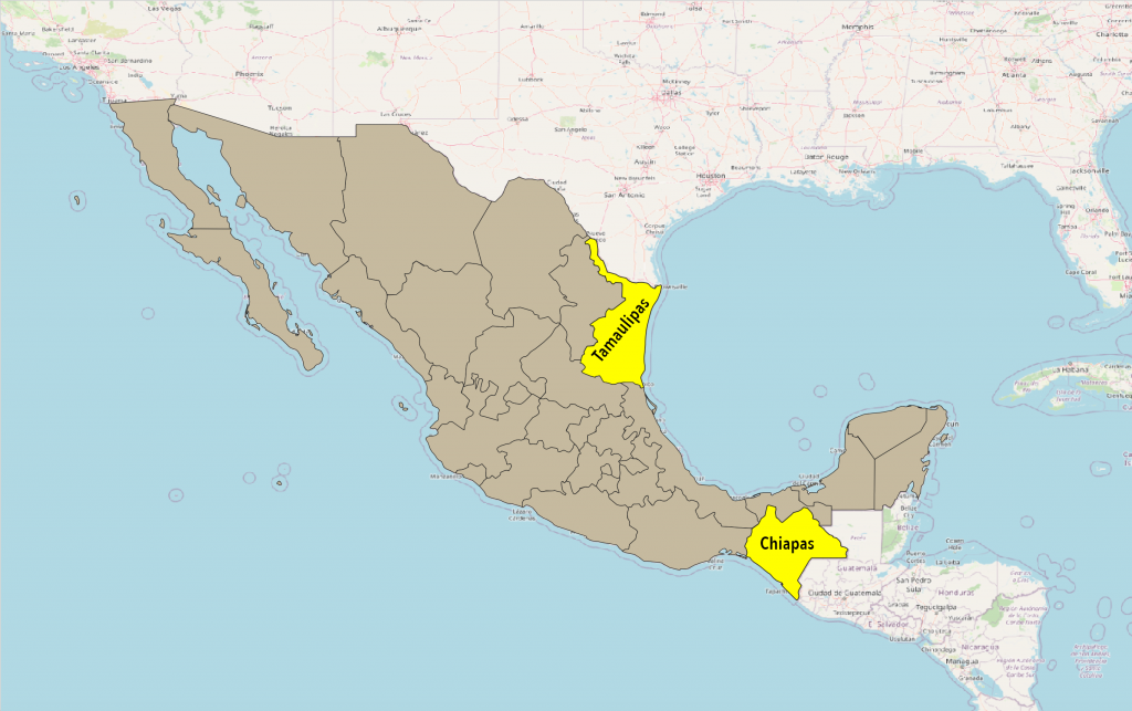
If that’s not enough, do you know how many states separate Tamaulipas and Chiapas? Just a single one: the State of Veracruz.
9. The Antelope Hills, which are a cluster of small buttes in western Oklahoma, once marked the US-Mexico Border
In the early 1800’s, the Antelope Hills marked the border between the United States’ Indian Territory, which is currently Oklahoma, and Mexico’s Alta California Territory. Alta California covered what is currently parts of California, Arizona, Nevada, Utah, Colorado, and the Texas Panhandle. The Antelope Hills currently sit on the Black Kettle National Grassland in Roger Mills County, Oklahoma, and are on the National Register of Historic Places.
And now for the cherry on top…
10. Mexico City was the administrative capital of the Philippines for almost 300 years.
Yes, you read that right. From 1565 until 1821, Mexico City was in fact the administrative capital of the Philippines. After Spain had settled both Mexico and the Philippines, they designated Mexico, under its then-name of New Spain, to directly govern the Philippines until Mexico’s independence in 1821.
You can still see this influence in the Philippines today. Most states and many cities in the Philippines still have Spanish names. There is even a municipality called Mexico in the Philippines’ Pampanga state. It sits between the towns of Ángeles and San Fernando.
Bonus Fact: The Caesar Salad was invented in Mexico
Okay, this is not a geography fact, but it’s a pretty cool fact nonetheless. Italian-American Caesar Cardini invented the salad at his restaurant in Tijuana in 1924. Supposedly, he originally called it the Aviator’s Salad.
I’m planning to make this “Weird Geography” series a routine occurrence for at least the remainder of the pandemic, and hopefully beyond, so if you have any requests for countries, states, or other entities you want me to feature, please leave them in the comments below.
Top Photo: Mexican Flag Flying at the Visitor’s Center of La Reserva de la Biosfera El Pinacate y Gran Desierto de Altar near Puerto Peñasco, Sonora in July, 2017