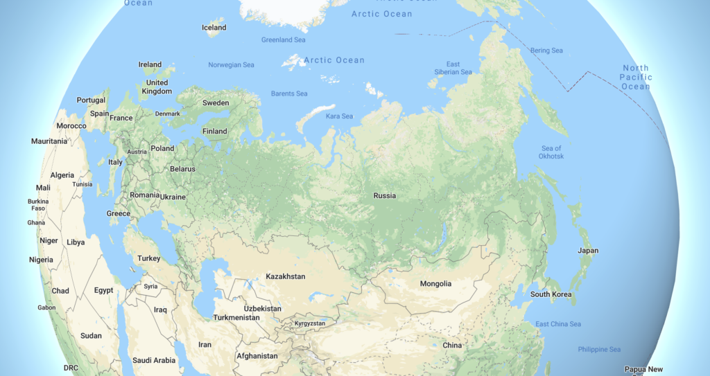
It’s been a couple of months since the most recent edition of the Weird Geography series took us to France, and I don’t know about you, but I’m certainly ready to (virtually) get back on the road. It’s been a miserably hot summer here in Arizona, so I’m thinking we should head somewhere that’s well-known for being really cold. While France is known for having territories and overseas departments scattered all over the world, today we’ll be exploring the geography of the largest country in the world: Russia.
1. Russia spans 11 time zones and is permanently on Daylight Saving Time
Did I mention Russia is a big country? When Vladivostok is heading to work in the morning, Moscow is just sitting down to dinner. To put the time zones into perspective, Boston and Bangkok are 11 hours apart. When it’s 7 PM in Boston, it’s 6 AM in Bangkok.
2. Russia shares a land border with 14 other countries.
Amazingly, it does not stand alone in bordering the most number of countries. China also shares a land border with 14 other countries. Russia’s longest land border is with Kazakhstan, which checks in at 6,847 km (4,254 mi), while Russia’s shortest international border is its 17 km (10.5 mi) border with North Korea.
And speaking of international borders…
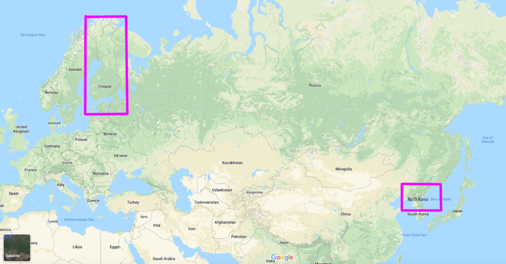
3. You can travel over land from Finland to North Korea and only pass through a single country.
Despite Helsinki and Pyongyang sitting nearly 7,000 km (4,300 mi) apart as the crow flies and having a six-hour time difference, Russia is the only country that separates the two. However, this journey is impossible in reality since there are no legal border crossings between Russia and North Korea. Maybe I should have used China as the example instead.
4. At their closest points, Russia and the United States are only 4 km (2.5 mi) apart.
The Diomede Islands sit in the middle of the Bering Strait between Wales, Alaska and Naukan, Russia (Наукан). Big Diomede is a Russian island, while Little Diomede is part of Alaska. In a true geographical oddity, the two islands sit just under 4 km (2.5 mi) from each other, and due to the International Date Line running between them, there is a 21-hour time difference between Big and Little Diomede.
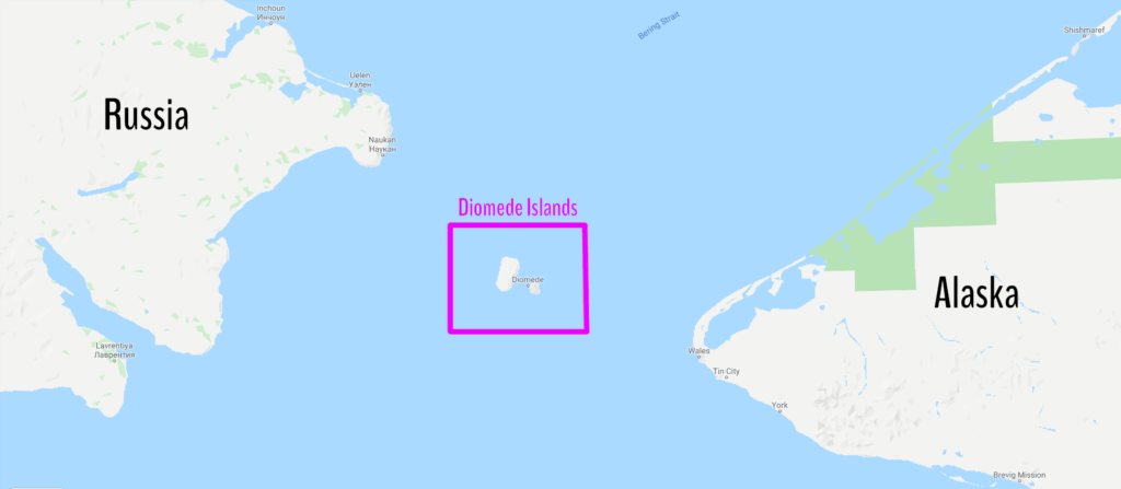
Bonus Fact: The mainland-to-mainland distance between Wales, Alaska and Naukan, Russia is 80 km (50 mi). For perspective, the width of the Phoenix metro (measured from Goodyear to Apache Junction) is about 90 km (55 mi).
All right, enough about borders, let’s move on.
5. Russia is home to the coldest town on Earth
The Siberian town of Oymyakon (Оймякон) lays claim to being the coldest inhabited place on Earth. The town has very unique terrian and topography, as it sits in a river valley surrounded by mountains. The valley traps frigid air year-round, creating the extremely cold climate in town.
Not surprisingly, winters in Oymyakon are brutal, with average winter high temperatures hovering around -43°C (-45°F). Low temperatures between November and March routinely drop below -50°C (-58°F).
The second coldest temperature ever recorded on Earth was recorded at Oymyakon on 6 February, 1933, when the mercury dipped to -67.7°C (-89.9°F). Oymyakon’s weather station has been in operation since the 1920’s and has never recorded a temperature above freezing between 25 October and 17 March. Only Antarctica has recorded colder temperatures than Oymyakon.
Bonus Fact: On 28 July, 2010, Oymyakon measured its all-time record high of 34.6°C (94°F). When coupled with its all-time record low mentioned above, it has a temperature range of 102°C (184°F). The Russian towns of Verhoyansk, Yakutsk, and Delyankir, along with Fort Vermillion, Alberta, Canada are the only other places on earth that have observed a temperature range greater than 100°C.
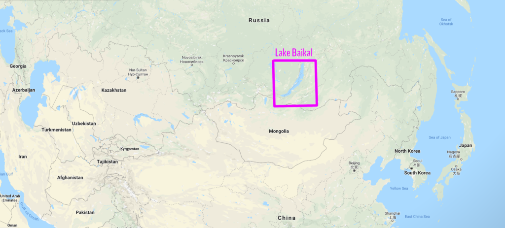
6. Russia is home to the world’s largest and deepest lake, which contains over 20% of the Earth’s fresh water.
Lake Baikal (озеро Байкал) sits on the border between the Irkutsk Oblast and the Buryat Republic in southern Siberia. At 636 km (395 mi) long with a maximum depth of 1.64 km (5,387 ft), it contains more water than the Great Lakes combined, with a volume of 23,615 cubic km (5,670 cubic mi). Baikal is also considered to be the world’s oldest, cleanest, and clearest lake, and is home to thousands of species of plants and animals. You can often see the bottom in depths up to 30 to 40 meters (100 to 130 ft), especially in the wintertime.
The lake was declared a UNESCO World Heritage Site in 1996, and is a top Russian tourist destination year-round.
7. There is a part of Russia wedged between Poland and Lithuania
Formerly part of East Prussia and Germany, the Kaliningrad Oblast (Калининградская область) is an isolated exclave of the Russian Federation sitting between Poland and Lithuania. In January 1945, the Soviet Union invaded and annexed all of East Prussia except for the city of Königsberg. After the Nazis were defeated in 1945, the Germans agreed to cede the city to the Soviets.
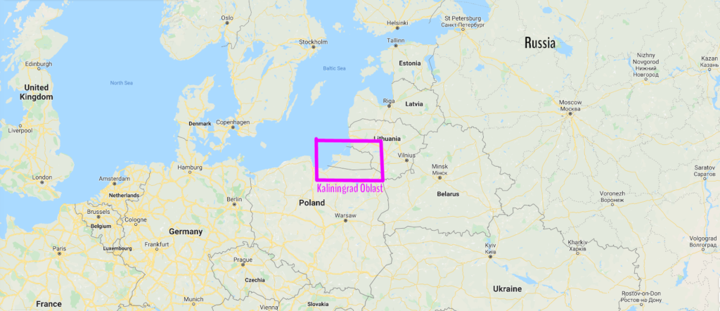
In 1946, the Soviets changed the name of Königsberg to Kaliningrad. By 1950, the remaining German population had been forcibly expelled, and Russian replaced German as the oblast’s official language. When the Soviet Union collapsed in 1991, the Kaliningrad oblast was designated part of Russia. Kaliningrad has become even more isolated since Poland and Lithuania joined the European Union and significantly tightened their border security.
Today, Kaliningrad is the only Russian port on the Baltic Sea that is ice-free year round, and plays a strategic role in the Russian economy and military.
8. Moscow is closer to both Churchill, Manitoba and Libreville, Gabon than Ozernovskiy, Russia.
The expansive geography of Russia has been known to yield some facts so absurd it seems there’s no possible way they can be true. Libreville, Gabon sits just 43 km (27 mi) north of the equator in central Africa, while Churchill, Manitoba is on the Hudson Bay in Canada about 140 km (87 mi) south of the provincial border with the Northwest Territories.
What’s even harder to believe? The distance from Churchill to Libreville is 10,750 km (6,680 mi). Ozernovskiy (Озерновский) is located on the southern tip of the Kamchatka Krai, about 1,100 km (700 mi) northeast of Japan.
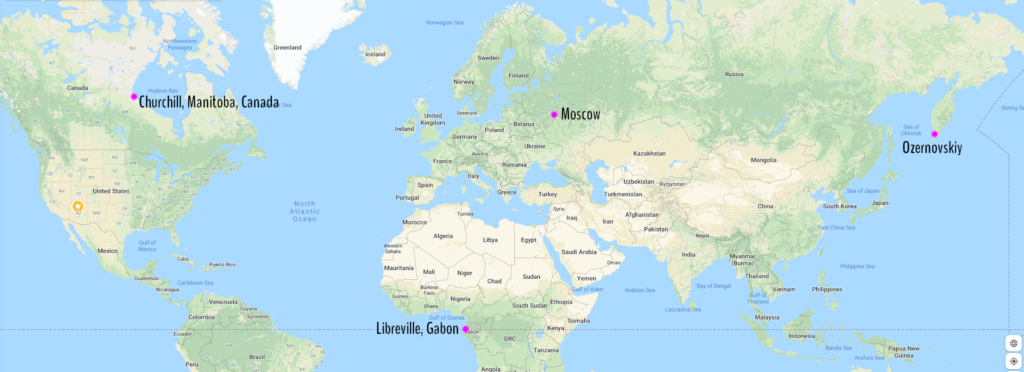
Here’s how the distances from Moscow break down:
| City | Distance from Moscow (km) | Distance from Moscow (mi) |
|---|---|---|
| Churchill, Manitoba, Canada | 6,584 | 4,091 |
| Libreville, Gabon | 6,659 | 4,138 |
| Ozernovskiy, Russia | 6,838 | 4,249 |
9. The US State of Alaska was once part of Russia
Have you ever heard someone say that Alaska stretches so far west it actually goes into the Eastern Hemisphere? Well, Russia once stretched so far east it went into the Western Hemisphere. Russia tried unsuccessfully to colonize Alaska, which was known as Russian America, before ultimately deciding keeping the territory was not profitable.
In 1867, the United States purchased Alaska from Russia for $7 million, in a deal known as Seward’s Folly. Ironically, Russia sold Alaska to the US because they saw Canada as a much bigger threat at the time. Some Russian town names, churches, and sayings remain preserved in Alaska to this day.
10. Russia is larger than the surface area of Pluto.
I can’t think of a scenario where this fact would be anywhere remotely close to useful, but it’s a cool statistic nonetheless, and would make for a really good trivia question. Pluto’s surface area is 16.7 million square kilometers, while Russia checks in at a whopping 17.1 million square kilometers.
Bonus Fact #1: The letters И and Я in the Cyrillic alphabet are actually vowels.
I’ve never quite understood why so many Americans think these are the Cyrillic letters for “N” and “R”. They’re just not. Both letters are actually vowels in all languages that use the Cyrillic Alphabet. The letter “И” is used basically the same way the letter “i” is used in English, while the letter “Я” makes a “ya” sound, which is common ending in many Russian words, including the Russian word for “Russia” – Россия – which is pronounced “Russ-ee-ya”.
Extra Bonus Fact: The Cyrillic alphabet is just the Greek alphabet with several extra letters to represent sounds in Slavic languages that are not used in Greek.
Bonus Fact #2: Bangladesh, which has 0.86% the land area of Russia, has a larger population.
Bangladesh, which covers roughly the same land area as the US State of Illinois, is one of the most densely populated countries in the world, while Russia, which has about twice the land area of Canada, is simply not.
| Country | Land Area (sq km) | 2018 Population |
|---|---|---|
| Bangladesh | 148,460 | 161.4 million |
| Russia | 17,098,242 | 144.5 million |
Well, that wraps up our geography adventure through Russia. Stay tuned for our next weird geography adventure, which will be a special spin-off of this rendition. Thanks for joining me, and I’ll see you next time. Спасибо. Увидимся в следующий раз.
Top Photo: An icy Vineyard Sound and Woods Hole Passage following a major blizzard
Woods Hole, Massachusetts – February, 2015