You’ve probably heard a lot about the severe drought in California on the news over the past few years. And if you’re like most people who don’t live there, you probably just shrugged it off. It wasn’t a direct threat to your daily life. The seriousness of the drought didn’t truly hit me until I traveled to California for the first time since the start of the COVID-19 pandemic. And that’s coming from someone who has called Arizona home for the past six years and has travelled extensively throughout the western United States during that time.
Anthony Bourdain once famously said, “Travel changes you. As you move through this life and this world you change things slightly, you leave marks behind, however small. And in return, life — and travel — leaves marks on you.” Travel has left plenty of marks on me over the years. However, this quote really hit home after a recent road trip I took through California. Today, I want to share that story with you.
What Causes Severe Drought in Western States Such as California?
Most people attribute drought to the lack of rain. However, it’s actually not the primary cause of severe drought in the western United States. To find the culprit, you need to look in an unexpected place. In fact, you’ll find it in the exact opposite of the summer season that makes headlines for searing temperatures and massive wildfires.
The winter season actually determines how severe the drought will be in California and throughout the west. More specifically, the amount of snow that falls in the mountains is what drives drought levels. In the spring, the snow melt feeds rivers, streams, and creeks, providing water to the valleys below. Unlike a rainstorm, snow melt is a slow process that provides a steady supply of water for months. And for many rivers, snow melt is their only source of water.

Most of California’s mountains snows fall in the Sierra Nevada. Rising over 14,000 feet above sea level, the Sierra runs pretty much the entire length of California’s eastern border with Nevada. During normal winters, pretty much every snow event in the Sierras is measured in feet, not inches. Snow melt from the Sierra Nevada alone provides water over 25 million Californians – about 65% of the state’s population.
The California Drought: Data and Statistics
Before diving into the drought data for the entire state of California, let’s have a look at annual snowfall in the Sierra Nevada over the past ten years. We’ll at two hotspots for heavy snow. First up is Donner Pass, which sits along Interstate 80 just west of Truckee and northwest of Lake Tahoe. Then, we’ll look Mammoth Mountain, one of California’s most popular ski resorts. Mammoth Mountain sits about 45 miles (72 km) southeast of Yosemite National Park.
| Winter | Donner Pass | Mammoth Mountain |
|---|---|---|
| 2012 – 2013 | 13 in / 33 cm | 315 in / 800 cm |
| 2013 – 2014 | 33 in / 84 cm | 192 in / 488 cm |
| 2014 – 2015 | 14 in / 35 cm | 161 in / 409 cm |
| 2015 – 2016 | 289 in / 734 cm | 393 in / 999 cm |
| 2016 – 2017 | 474 in / 1,204 cm | 608 in / 1,544 cm |
| 2017 – 2018 | 225 in / 572 cm | 277 in / 704 cm |
| 2018 – 2019 | 381 in / 968 cm | 495 in / 1,258 cm |
| 2019 – 2020 | 180 in / 457 cm | 153 in / 389 cm |
| 2020 – 2021 | 129 in / 328 cm | 225 in / 572 cm |
| 2021 – 2022 (To Date) | 179 in / 455 cm | 178 in / 453 cm |
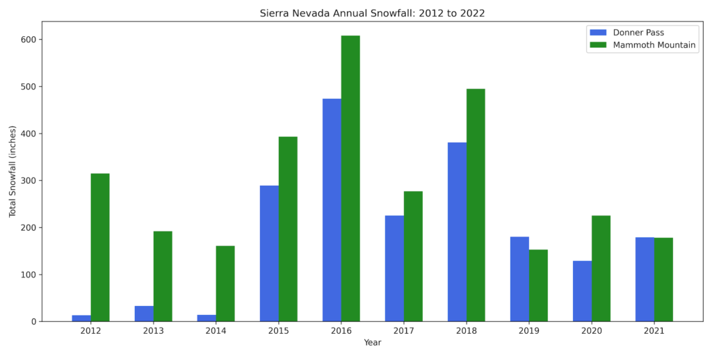
Snowfalls are Way Down in Recent Years Throughout the West
From the bar chart, it’s pretty clear that snow levels in the Sierra Nevada are way down every year since 2018. This pattern is echoed across mountain ranges throughout the west, from Washington to New Mexico. As a result, water levels have plummeted across the entire region due to the lack of snow melt. The southwestern states, plus California have born the brunt of the recent drought.

To further compound the matter, smaller snowpacks mean that the snow melts faster. In 2021, snowpack across the entire state of California had completely melted by May, about two to three months earlier than average. The faster rate of snow melt results in most of the water running off instead of being absorbed into soils that so desperately need it.
As you can probably deduce, dry soils lock a layer of extremely dry air at the surface throughout the summer months. Unfortunately, that only makes it harder for much needed rain to reach the ground. Much of California is caught in this vicious positive feedback loop that only makes the drought worse.
An Anthony Bourdain Quote and a Trip Up Interstate 5 Makes the Severity of the California Drought Really Hit Home
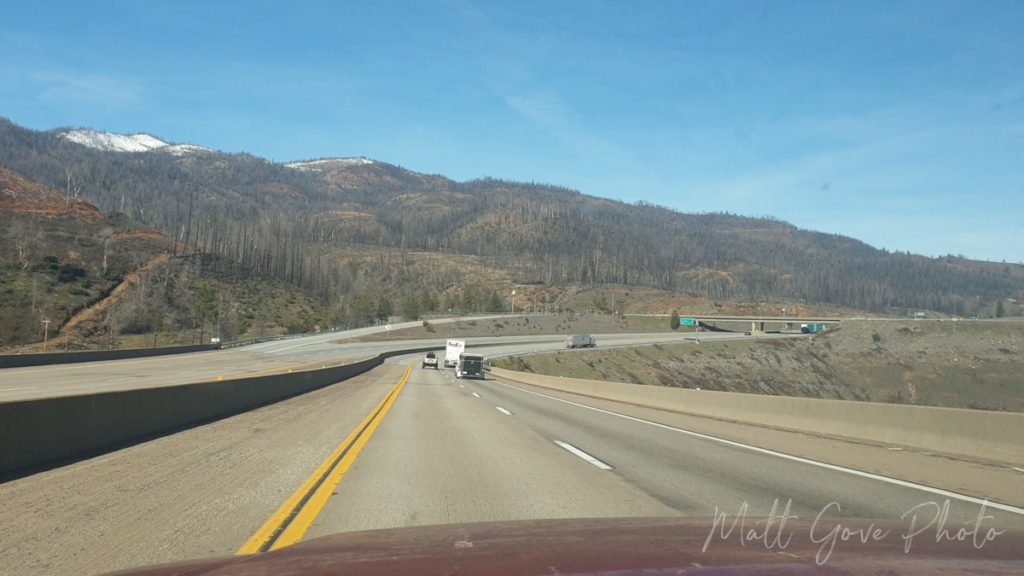
In January 2022, I took a road trip from Las Vegas to Salem, Oregon. Coupled with a stop to visit one of my best friends in San Francisco, the trip took me across nearly the entire state of California. It marked my first visit to California since February, 2020.
During that time, both the drought and wildfires have gotten exponentially worse, thanks to a lack of snowpack in the mountains. And seeing areas that were so lush and vibrant in 2017 now completely ravaged by drought and wildfire really left a big mark on me. In ways that really didn’t expect.
“Travel changes you. As you move through this life and this world you change things slightly, you leave marks behind, however small. And in return, life – and travel – leaves marks on you.”
Anthony Bourdain
A Stunning Drive Through California’s Central Valley
If you’ve never driven through California’s Central Valley, it’s one of the more uniquely spectacular drives in the United States. Responsible for 8% of the United States’ agricultural output, the Central Valley features lush and fertile fields surrounded by majestic mountains. It’s hard to not feel a special connection to nature. And if you drive through at the right time of year, the smell of fresh fruits and vegetables is heavenly.
Furthermore, when I drove through in mid-January, farmers were in the process of prepping and seeding their fields for the spring and summer growing seasons. Passing through the Central Valley was like a cleansing and rebirth for you mind and soul. At times, you felt like you were in a fairy tale, having been teleported to some faraway land. The pandemic and all the other problems in the world felt so far away.

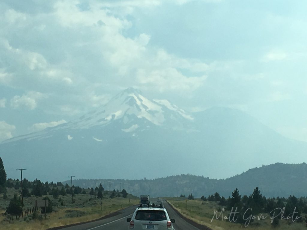
A Stunning Snow-Capped Mt. Shasta Completes the Fairy Tale
Towering 14,179 feet above sea level and over 10,000 feet above the surrounding terrain, Mt. Shasta dominates the northern California landscape. It’s the second tallest mountain in the Cascades, behind only Mt. Rainier. And Rainier is only 250 feet taller. On a clear day, you can see Mt. Shasta from as far as Central Oregon, over 140 miles away. You can actually find some of the best views of Mt. Shasta right from both US-97 and Interstate 5.


Surrounding Mt. Shasta, you’ll find simply breathtaking scenery. Golden meadows, stunning rolling hills, and refreshing pine forests transport you even further into that fairy tale. All those worries you had to start the day seem even further away than they did down in the Central Valley.
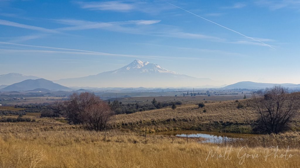
As a photographer, I try to keep an eye out for good photo ops on road trips. However, a truly spectacular composition catches your eye right away. Shortly after beginning the climb out of the Central Valley up into the Cascades, I came around a corner on Interstate 5 and into a clearing. And what lay before me was one of the most perfectly composed landscapes I had ever seen.
Off in the distance sat Mt. Shasta, perfectly framed between two smaller mountains. It provided a beautiful backdrop for seemingly endless meadows and rolling hills that disappeared into a light haze that shrouded the base of the mountain. Small ponds dotted the foreground on the side of the freeway, adding even more diversity to the shot. It was a combination of beautiful, mysterious, and exotic, balanced to perfection. The perfect composition to capture the fairy tale I had drifted off into.
You Can’t Stop on the Freeway to Take Pictures
Unfortunately, I also had a few things working against me. Most critically, I was cruising at 70 miles per hour up Interstate 5. There were no exits or pullouts nearby, and I wasn’t about to stop in the middle of a busy freeway just to take a picture. Furthermore, there was no safe way for me to take a picture with my DSLR camera while I was driving. But I wasn’t going to let this perfect photo op go to waste.
While using my big camera was out of the question, I still had one more tool available to me. And at this point, it was really my only option. I grabbed my phone, rolled down the passenger side window, leaned over far enough to get the window frame out of the picture, and blindly started snapping as I kept looking forward to keep my eyes on the road.
I expected to get a decent shot. What I didn’t expect was to get one of the best photos I’ve ever taken, and one that will be put up for sale in our store very soon.
Then reality hit, hard. Like being hit by a Mack truck hard.
A California Landscape Ravaged by Wildfire and Drought
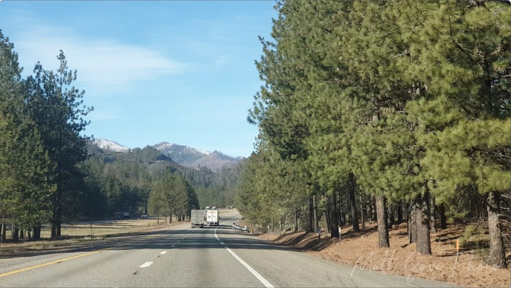
Over the past five years, parts of the Shasta-Trinity National Forest have been devastated by several major wildfires. The extreme drought that has suffocated California for much of that time has only made these fires larger and more intense. Most notable, the Carr Fire torched nearly 230,000 acres in the summer of 2018, forcing 38,000 people to evacuate their homes. It killed 11 people and caused $1.7 billion in damage.
Fast-forward three years. In late June, 2021, another fire broke out along Interstate 5 just north of Lake Shasta. That blaze, dubbed the Salt Fire, torched 13,000 acres on both sides of the freeway. While few people live in the area, the intensity of the fire devastated the landscape, changing it into a barren wasteland for years to come. The drought is one of the prime culprits behind the increase in both intensity and magnitude of these fires in California. But it’s not the only culprit. And there were far more blazes than just the two we’ve discussed here.
From Lush Forest to Charred Hellscape
Like many natural disasters, you simply cannot grasp the scale of these California wildfires from newscasts on television. The only way to properly do so is by traveling to the burn area and seeing the devastation firsthand. And when you’re driving through lush green forests, it hits e0ven harder when it catches you by surprise. Which is exactly what the burn scar from the Salt Fire did. You come around a corner, and bam, the landscape instantly changes.
The Salt Fire completely incinerated everything in its path. It wiped entire parts of the National Forest completely off the map. It was just blackened hills and a few remaining trunks of the trees that had burned. Everything else was gone. As far as the eye could see. Even six months after the fire, the smoky smell of burnt wood still faintly hung in the air.
Combined with the Wildfire Devastation, the California Drought at Lake Shasta Really Left Its Mark on Me. It Should Leave its Mark on You, Too.
The second I drove into that burn scar north of Redding, it instantly ended that fairy tale from the Central Valley. But interestingly, it didn’t leave as big a mark as you would have thought. For that, it took driving across the bridge at Lake Shasta to see the true effect the drought and the fires have had on California. It hits hard and it hits heavy, but it’s a series of pictures everyone should see.


View of Lake Shasta from Interstate 5 in August, 2017 (left) vs January, 2022 (right). Click on the image to enlarge.
And while the water level in the lake should be what instantly catches your eye, did you notice the mountains behind the lake in the 2022 picture? They were all burned in the recent fires. It’s hard to see in the 2017 photo because the lake was shrouded in smoke, but the forest was lush green back then.
Conclusion
As Anthony Bourdain so famously said, travel changes you and leaves its mark on you. But at the same time, it gives us the opportunity to leave our mark on it. We can use these experiences and lessons to influence our own decisions. The vast majority of wildfires in the United States are the result of human error. We can make better decisions to help prevent states like California from burning, as well as reduce the effect of severe drought. What steps will you take?
To wrap this all up, let’s go full circle and end with another Anthony Bourdain quote: “Travel isn’t always pretty. It isn’t always comfortable. Sometimes it hurts, it even breaks your heart. But that’s okay. The journey changes you; it should change you. It leaves marks on your memory, on your consciousness, on your heart, and on your body. You take something with you. Hopefully, you leave something good behind.” What good will you leave behind? Let us know in the comments.
If you want to stay up-to-date with our latest adventures or want more travel guides, please consider signing up for our email newsletter. We’ll send these travel guides, plus exclusive deals, tutorials, and much more, straight to your inbox, twice per month, all for free.
Top Photo: Low Water Levels Due to Severe Drought
Lake Shasta, California – January, 2022