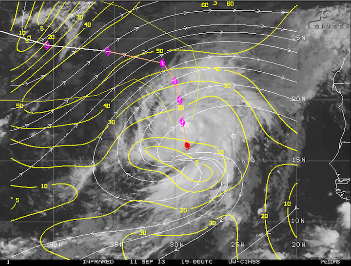
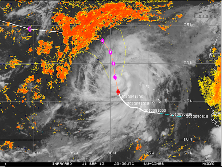
We officially have our first hurricane of the 2013 Atlantic season. Earlier this morning, Humberto was upgraded to a hurricane, coming within a few hours of the Atlantic record for latest first hurricane. Humberto currently sits over the far eastern Atlantic, right off the west coast of Africa, and is not a threat to land at this time. It has maximum sustained winds of 80 mph and is forecast to move north over cooler waters before making a turn to the west. It may strengthen a little more over the next day or so, but will likely weaken back to a tropical storm once it gets over the cooler water, where it will also be encountering drier air and stronger shear.

Humberto Forecast Track and Shear

Humberto Satellite with Mid/Upper-Level Dry Air in Orange
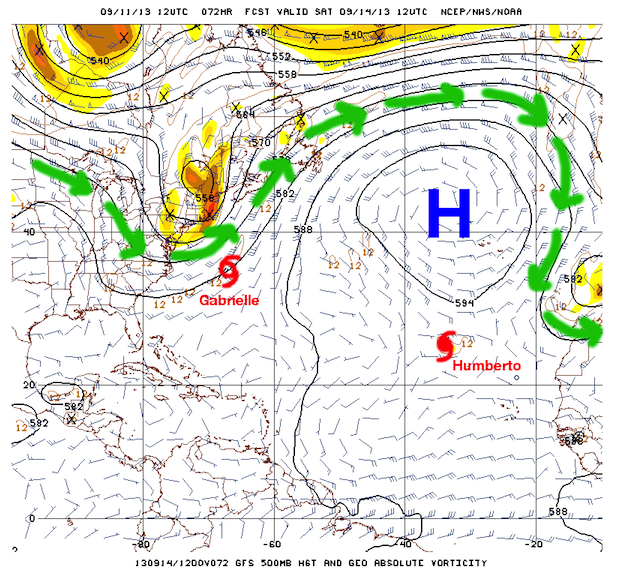
One reason the Atlantic season has been so quiet is due to a very strong area of high pressure over the central Atlantic (also called the Bermuda High), which is marked by the big blue “H” in the figure below. That Bermuda High has been so strong that the sinking motion in the upper levels of the atmosphere associated with the high had spread far enough south to prevent thunderstorm formation and intensification in the tropical waves that come off the African coast. The Bermuda High is starting to weaken and move further to the north and east, allowing for the formation of both Gabrielle and Humberto.

GFS 72-Hour 500 mb/Upper Level Forecast (valid Sept. 14) of the Atlantic Basin
Speaking of Gabrielle, that storm is currently positioned just west of Bermuda as a minimal tropical storm, and while it is not a threat to the United States, it may impact parts of Nova Scotia and Newfoundland as a post-tropical low. As Gabrielle gets absorbed by the jet stream (which is indicated by the green arrows) off the east coast of the United States, it will lose its tropical characteristics and may weaken further, so I would not expect to see winds much stronger than 40-45 mph when it impacts the Canadian coast.
The jet stream will also act to steer Gabrielle away from the United States. The easiest way to think of the jet stream is to think of it like a conveyor belt of air, and anything that it picks up or absorbs, such as Gabrielle, will just ride along it like you would ride a raft down a river. The raft can’t flow upstream, and the tropical storm can’t flow against the jet stream either.
Looking into the future, it would not surprise me to see activity in the Atlantic increase in the short-term as the Bermuda High weakens and moves away, but if it can re-establish itself anywhere near as strong as it was in August, things will quiet down again. Do not let your guard down if you live in a hurricane-prone area. Remember how quiet the tornado season was in Oklahoma this spring until all hell broke loose in the last two weeks. I’m not saying that’s going to happen with the hurricane season, but you should be prepared just on the off chance it does. The long-term GFS model indicates that the Bermuda High will be much weaker over the next 10 days to two weeks, but whether that helps lead to an uptick in tropical cyclone activity remains to be seen.