A big blast of arctic air is set to invade the Great Plains the next few days, bringing the chance for winter precipitation to parts of the region. I am not expecting this to be a significant storm, but it will bring very cold temperatures and the chance of all forms of winter precipitation: snow, sleet, and freezing rain.
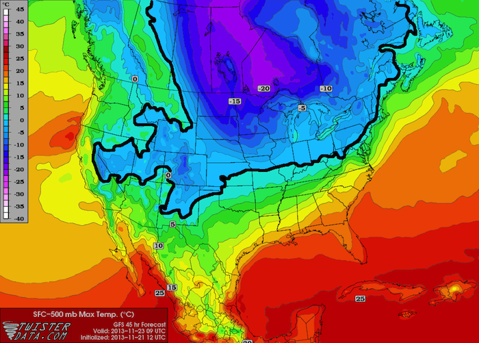
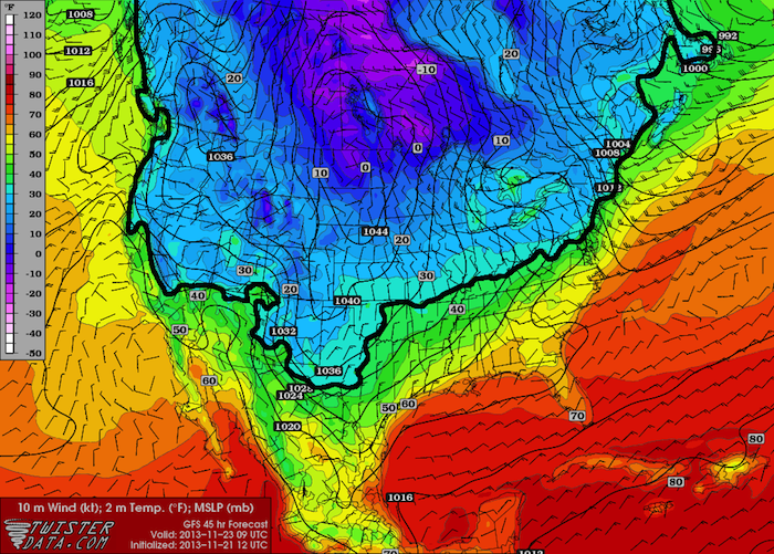
Determining exactly what type of precipitation will occur where and how much accumulation there will be is very difficult. If we look at the big picture, one way to be able to at least make an educated guess as to what type of precipitation will fall is to look at the Surface – 500 mb (About 17,000 feet) max temperature and the surface temperature predictions. These maps are for Saturday morning at 3 AM CST, which the GFS model is currently indicating has the highest probability to see both cold temperatures and precipitation. The thick black line marks approximately the freezing isotherm.
 Sfc-500 mb Max Temp (°C)
 Surface Temperature (°F)
If you are below freezing on both maps, you will more likely than not see snow. If you are above freezing on both maps, you will likely see rain. If you are above freezing on the Surface-500 mb max temperature map, but below freezing on the surface map, you will likely see either sleet or freezing rain. It is impossible to determine whether you will see sleet or freezing rain just by looking at these two maps.
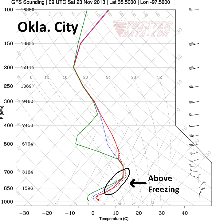
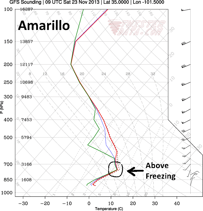
The easiest way to get a better grip on whether you’ll get sleet or freezing rain is to look at soundings. The following are GFS Forecast soundings for Oklahoma City, OK and Amarillo, TX for 3 AM CST Saturday.


The first thing that really jumps out is the depth of the warm (above freezing) layer. At Oklahoma City, the warm layer is close to 200 mb (about 6,000 ft) deep, while at Amarillo, that same layer is only 75 mb (about 3,000 ft) deep. The other key ingredient is how high that warm layer is. Even when we take into account that the elevation of Amarillo is about 2,500 feet higher than Oklahoma City, the warm layer is much higher compared to the surface at Amarillo than it is at Oklahoma City. If these models verify, I would expect sleet in Amarillo with a shallow, elevated warm layer, while I would expect freezing rain in Oklahoma City with a deep and much lower warm layer.
In situations like this, a small change in temperature at any given height can mean a big change in what type of precipitation falls and its subsequent impacts. Forecast soundings for Guymon, OK (in the panhandle) show all layers below freezing, which means folks there are more likely to see snow, but again, it’s so close that if any of the lower levels are warmer than what the model says, they could easily end up with sleet or freezing rain. The good news is that since it has been in the 60s and 70s all week, the ground is so warm that nothing will stick, but I would expect to see some light ice/snow accumulations on elevated surfaces such as bridges/overpasses, trees, and powerlines.
Stay tuned for more info. Things change very fast with these types of storms. There’s a second round of precipitation coming in between Sunday and Tuesday, so I will be posting more as we get closer.