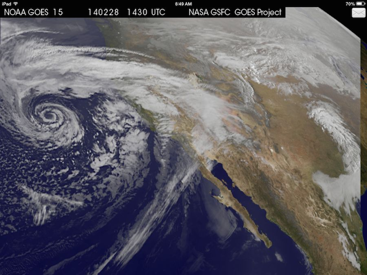
Cloudy with a change of cinnabons? No, Jim Gaffigan is not coming to your neighborhood. Nor will tasty baked goods be falling from the sky (how awesome would that be though). Instead, one of the most impressively beautiful and textbook upper-level mid-latitude storm systems in recent years is currently coming ashore in California. The structure of this storm system is so perfect it looks like a cinnabon on the satellite image. The storm is big enough to bring rain to the entire west coast, but the most rain will fall in the drought-striken areas that need it most.

GOES Satellite Image – Friday at 6:30 AM CST/4:30 AM PST
Storm Brings Much-Needed Rain to Drought-Stricken California
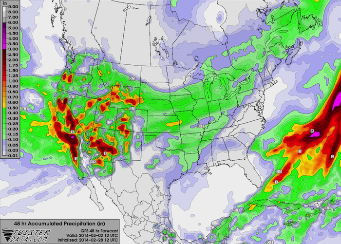
The best news is that this storm will bring some much-needed rain to the areas in California that have been hit so hard by drought this winter. May areas from the Central Valley area all the way down the Interstate 5 corridor to the Mexican border could see up to 2 inches of rain. Temperatures in the valleys and at the coast will be in the 40s and 50s, so winter weather is not a threat at the lower elevations. Unfortunately, whenever you get a large amount of rain falling over a drought-stricken area in a short period of time, flash flooding and landslides will be a concern, especially in areas recently impacted by wildfires.
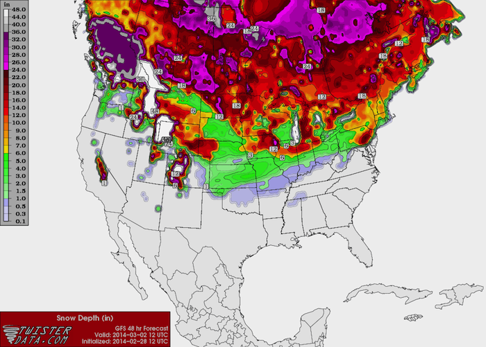
Conditions up in the mountains will be a vastly different story. Strong winds and heavy snow will create dangerous conditions across the Sierra Nevadas to the south and southeast of Lake Tahoe, including Yosemite National Park and Mammoth Lakes. A Winter Storm Warning is in effect for much of these areas above 6,000 feet until 4 PM PST Saturday. With wind gusts up to 80 mph possible and and snow accumulations of 12 to 24 inches possible, it would not surprise me if this was upgraded to a Blizzard Warning later on. Further to the south where snow is less of a threat, a High Wind Warning is in effect for the Kern County Mountains and the Interstate 5 corridor through The Grapevine until 4 PM PST today. South winds of 30-50 mph with gusts to 90 mph are possible.

GFS Forecast Rainfall/Liquid Equivalent Through 4 AM PST Sunday

GFS Forecast Snowfall Totals Through 4 AM PST Sunday
What Lies Ahead for this Storm After California
Like many of these storms, it will weaken as it crosses the Rocky Mountains and its supply of moisture is cut off. As it ejects over the southern plains, it will interact with an Arctic airmass plunging southbound out of Canada. As a result, it will bring light winter precipitation (snow, sleet, and freezing rain) and a cold rain to parts of Kansas, Oklahoma, and north Texas. In Oklahoma, freezing rain and sleet will be the primary modes of precipitation, with up to 1/10 of an inch of ice accumulations possible with locally higher totals, especially across eastern Oklahoma. Heavier snow totals will be possible up in Kansas, with mainly rain to the south down in Texas.
The storm will continue to move to the ENE once it crosses the central and southern plains. The exact location, timing, and intensity of the storm once it reaches the east coast is still very much up in the air, so stay tuned. Right now, there is the potential for heavy snow near the east coast, but it appears to be confined to a fairly localized area if it does indeed happen. The models should be able to get a much better grip on the storm once it comes ashore and the Weather Service can get accurate data from inside of it.