I am watching two possible areas for winter weather over the next three to four days. The first is a coastal storm that may bring some gusy winds and light snow to the northeast Sunday, and the other is an upper-level storm system that could bring more snow and ice to the southern plains and lower Mississippi River Valley.
Outlook for New England
A weak disturbance has been tracking eastbound down Interstate 40 for the past few days. That system dropped 1 to 3 inches of snow on Friday over parts of eastern Oklahoma, Arkansas, and North Texas. As of 7 AM EST today, the upper-level disturbance was centered near Memphis, Tennessee, and should be centered near the Tennesee – North Carolina border by daybreak on Sunday. Temperatures south of northern Virginia will be above freezing, so any precipitation will fall as rain the Carolinas Sunday morning. Any precipitation that falls will be very light, if it falls at all. The heavier precipitation will be well offshore.
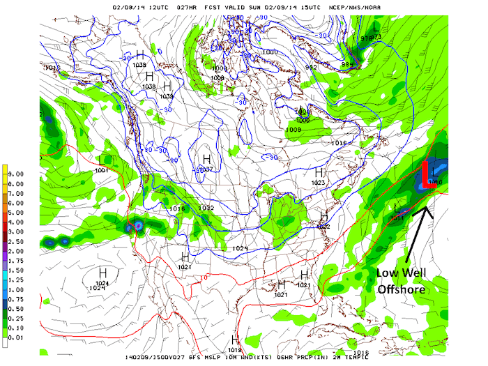
Also beginning Sunday morning, a surface low will begin to develop off the Mid-Atlantic coast. Some of the GFS runs from earlier today brought the system right up the east coast, but this morning’s run is much more in agreement with the Eurpoean model. Both models are now showing the surface low developing well offshore and moving northeast, staying sufficiently offshore of the east coast of both the United States and Canada. The surface low is being “sling-shotted” around the upper-level trough, so it is moving faster and will be further offshore than models earlier this week were showing.

Sfc Wind/Pressure/Precip – Saturday at 7 PM EST

Sfc Wind/Pressure/Precip – Sunday at 10 AM EST
The storm may pass close enough to the coast to bring some gusty winds and light snow to eastern New England, but this will not be major system, and I am not anticipating any significant travel issues at this time. Wind gusts could be as high as 20-25 knots, and any snow accumulations will be minimal (less than 1 inch).
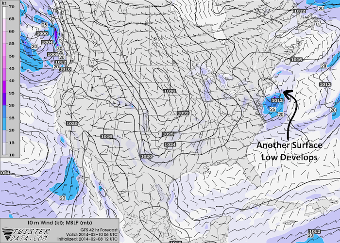
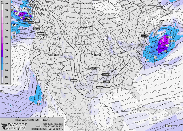
Another surface low may develop just south of New England late Sunday night into Monday and rapidly move northeast. This system could bring 20-30 knot winds and a few inches of snow to southern New England. Precipitation should end by Monday afternoon, but some gusty winds may remain through Monday night. The models are not in agreement with this system (some don’t even develop this low at all), so stay tuned.

Sfc Wind/Pressure – Monday at 1 AM EST

Sfc Wind/Pressure – Monday at 1 PM EST
Southern Plains
After another Arctic cold front comes racing down the plains on Sunday, another disturbance will eject across the southern plains on Monday. Models are currently hinting that any precipitation that falls Monday morning along and south of Interstate 40 in Oklahoma may start as a winter mix before quickly changing over to all snow. Forecast soundings from the Oklahoma City Metro are showing that this changeover could occur as soon as sunrise, and depending on exactly when the precipitation starts, it could just start as snow, too.
Further to the south, a much deeper mid-level warm layer will be present, which will delay the changeover to snow to later in the day. Areas right along the Red River may not even make the transition at all. The good news is that the bulk of the precipitation should fall well north of this area, so widespread significant icing is unlikely. The highest precipitation totals appear to be in the NW, NE, and SE quadrants of Oklahoma, including the entire Oklahoma City Metro, and much of Arkansas. This could change as we get closer to the event, however.
As far as snowfall totals go, I would expect to see a lot of reports in the 1 to 3 inch or 2 to 4 inch range, but it’s still too early to talk specifics on exact locations. The Oklahoma City Metro will likely once again be right on the edge of lighter snow and heavier snow, so a small shift in track could mean a big difference in snow totals. A few isolated 5 to 6 inch totals may pop up in eastern Oklahoma and northern Arkansas. Keep in mind that these will likely change as the event approaches and things start to come into focus a bit better, so stay tuned for more.