It takes a unique weather setup to generate thundersleet and thundersnow. It takes an even more unique weather setup to generate thunderstorms with surface temperatures of only 12°F. In order to understand these setups, we need to make sense of the concept of an elevated or high base thunderstorm. These can include any type of thunderstorm, from your wimpy little garden variety thunderstorm to powerful supercells.
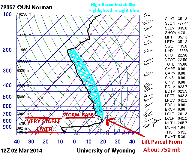
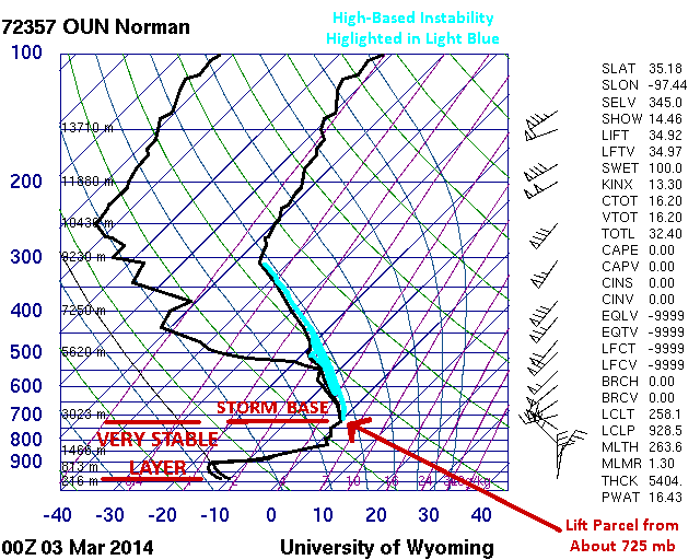
In the typical surface-based thunderstorm, warm, moist air is lifted from the surface or ground-level into the updraft of the thunderstorm. The cloud base of surface-based thunderstorms is typically only a few hundred feet above the ground. However, if we pass a powerful cold front through the area, such as we did right before the thundersleet, we create a very stable layer at and just above the ground level. In this case, that stable layer was only about 3500 feet deep, but that’s still plenty deep to prevent parcels from being lifted from the surface into the updraft. If we lift a parcel from the bottom of the unstable layer (just above 3500 feet), there is sufficient instability to form thunderstorms. The base of the thunderstorm will be a few hundred feet above the bottom of the unstable layer, which in this case would be around 3700 or 3800 feet above the ground (just under 5000 feet above sea level), hence the term high base thunderstorm (or elevated thunderstorm). This phenomenon can be showed very well in the Norman soundings from March 2nd.

Norman, OK Sounding – March 2nd at 6 AM CST

Norman, OK Sounding – March 2nd at 6 PM CST
A Few Observations from the Soundings
The line of convection formed about 15 miles south of the Norman sounding release site shortly after the 6 AM CST sounding. The high-based instability at 6 AM was strong enough to both create robust updrafts and sustain them throughout much of the day. One key observation that led to the formation of thunderstorms was that the temperature at the bottom of the unstable layer (750 mb or about 3500 feet) was around 50°F, warm enough to generate quite a bit of high-based instability in these conditions. The surface temperature is completely irrelevant for the formation of this type of high-based thunderstorm. The surface temperature could have been 50 below on March 2nd and thunderstorms would havve still been able to form.
By 6 PM CST, the bottom of the unstable layer had cooled from 50°F to 32°F and the mid-levels of the atmosphere had warmed, significantly reducing instability. While the thundersleet had ended hours earlier in Norman, the line of convection had moved to the east, but was quickly falling apart due to the lack on instability.
A Similar Event in 2013
A very similar event occured in northwest Oklahoma on April 9, 2013. That day began as a typical spring cold front/dryline setup for severe weather, and a couple surface-based supercells formed near the Texas/Oklahoma border south of Woodward, OK. A very shallow, yet very powerful cold front pushed through the area, dropping surface temperatures from the 70s into the upper 20s. However, there was so much instability aloft and the supercells were well-enough established that the front was not deep enough to cut off the updraft of the supercells. The result was that the supercells transitioned from surface-based to high-based and continued on their merry way, dropping tennis ball sized hail in the areas south of Woodward despite surface temperatures of only 27°F.
In the next posts, I will look at what caused the transition from snow to sleet as the thunderstorms passed, as well as look at some of the radar data from the event.