They say everything’s bigger in Texas. Speaking as someone who went to school in Oklahoma and has spent plenty of time in the Lone Star State, that saying is 100% true. In fact, if you’re talking about the State of Texas itself, it’s an understatement. Texas is huge. Let’s hit the road to learn about the more bizarre and unusual facts about Texas geography. While we’re there, don’t forget to try Texas’ world-famous steaks and barbecue.
1. If Texas were its own country, it would be the 40th largest in the world.
At over 695,000 square kilometers, Texas would fall between Zambia and Myanmar if you ranked countries by surface area. Additionally, Texas is bigger than Ukraine, France, Thailand, and Spain.
2. Contrary to the belief of a startling amount of people, Texas is not the largest state in the United States.
When you look at a map of the United States, it’s hard not to notice Texas. And while Texas is the largest state in the lower 48, it’s not the largest state in the US. That designation belongs to Alaska. At over 1.7 million square kilometers, Alaska would stretch from San Francisco to Jacksonville if you overlaid it across the lower 48.

3. The State of Rhode Island fits inside of Texas 174 times.
It’s always fun to see how many times the smallest state in the US fits into one of its largest. Figuring it out is nothing more than a simple math problem.
Texas covers an area of 695,662 square kilometers. Rhode Island is 4,001 square kilometers. To get the number of times Rhode Island, which we’ll call n, fits into Texas, we just divide Texas by Rhode Island.
n = TX/RI
n = 695,662 / 4,001 = 173.872
n = 174
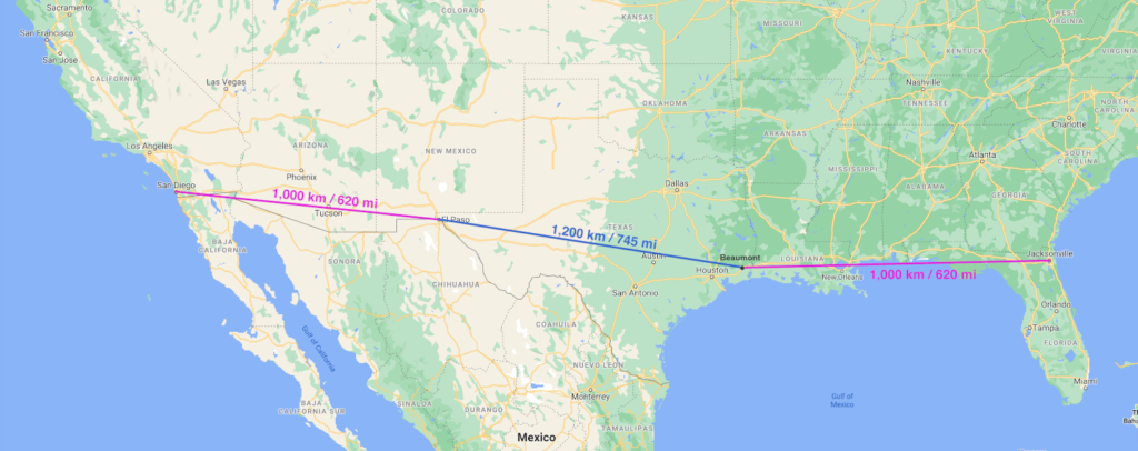
4. It is 1,000 km from Beaumont, Texas to Jacksonville, Florida. It’s also 1,000 km from El Paso, Texas to San Diego, California.
Yes, you read that right. You can drive only about 1,000 km (620 mi) from each end of Texas and reach both the Atlantic and Pacific Oceans. Though I must say, if you’re looking for the beach, it’s much easier just to stay in Texas. The Texas Gulf Coast is home to some of the best beaches in America.
And what’s even crazier? Beaumont and El Paso are closer to the east and west coasts, respectively, than they are to each other. As the crow flies, Beaumont and El Paso are about 1,200 km (745 mi) apart.
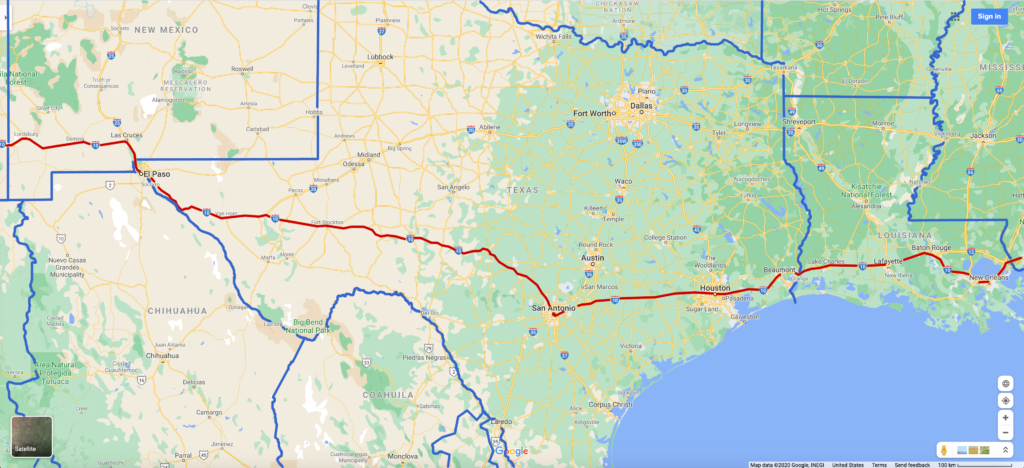
5. There are almost 900 miles of Interstate 10 in Texas. If you started in Greece and drove that distance, you’d cross 7 countries.
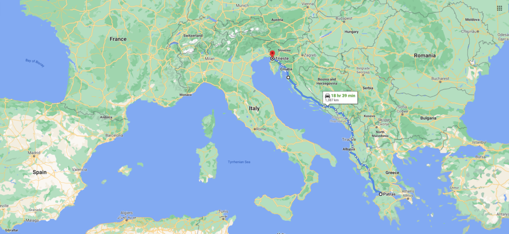
Interstate 10 is a major cross-country freeway running from Jacksonville, Florida to Los Angeles, California. About one third of it is in Texas. From Beaumont to El Paso, Interstate 10 runs for 1,420 km (880 mi) across Texas. You’ll pass through Houston and San Antonio as you transition from the swamps and bayous of the Gulf Coast to the Chihuahuan Desert.

For an international perspective, let’s start in Patras, Greece and drive north. After 1,420 km (880 mi), you will have passed through seven countries before winding up in northern Italy.
- Greece
- Albania
- Montenegro
- Bosnia and Herzegovina
- Croatia
- Slovenia
- Italy
To put Texas’ size into a better perspective, let’s stick closer to home. Start in York, Maine and drive south on Interstate 95. After driving for about 1,420 km or 880 mi, you will be in Dillon, South Carolina and will have crossed 13 states.

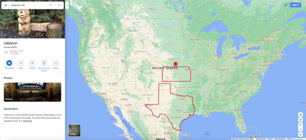
6. Texas is a border state. The geographical center of the United States is in Lebanon, Kansas. Just 50 km (30 mi) of the Oklahoma Panhandle separates Texas and Kansas.
In fact, back in the early 1800’s Texas and Kansas bordered each other. At the time, that border actually formed the US-Mexico border. Texas entered the Union as a slave state in 1845, but US law at the time prohibited slavery north of the 36°30′ parallel, which currently forms the state line between the Texas and Oklahoma panhandles.
As a result, Texas ceded the strip of land between the 36°30′ parallel and the Kansas border. At the time, it was not assigned to any state or territory, so it became known as “No Man’s Land”. It existed under several different names before officially becoming the panhandle of the Oklahoma Territory in 1891.
7. The Paseo del Norte is the 2nd largest transborder conurbation on the US-Mexico border and one of the largest binational metroplexes in the world.
Also known as The Borderplex, the Paseo del Norte is comprised of El Paso, Texas and Ciudad Juárez, Chihuahua, México. It is the largest binational and bilingual work force in the Western Hemisphere.

Despite the recent divisiveness along the US-Mexico border, El Paso and Juárez continue to function as a single community. People routinely cross the border in both directions every day to go to work, attend school, see the doctor, and much more. There are no two communities on the US-Mexico border that are as united as El Paso and Juárez.
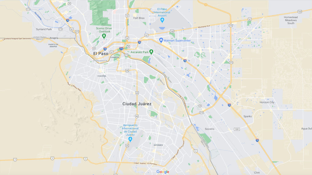
Any guess as to what the largest transborder conurbation on the US-Mexico border is? That distinction belongs to San Diego and Tijuana. The San Ysidro Port of Entry separating the two cities is the largest and busiest international border crossing in the world.
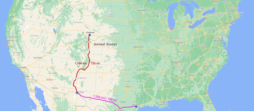
8. El Paso is closer to Cheyenne, Wyoming than Houston, Texas
El Paso sits in a unique location. The southern terminus of Interstate 25 is about 75 km (45 mi) northwest of downtown El Paso in Las Cruces, New Mexico. Continue north on I-25 through New Mexico and Colorado to Cheyenne, Wyoming. You will have driven 1,184 km (735 mi).
Alternatively, head east on Interstate 10 from El Paso. By the time you reach downtown Houston, you will have driven 1,202 km (750 mi). Did we mention Texas is big?
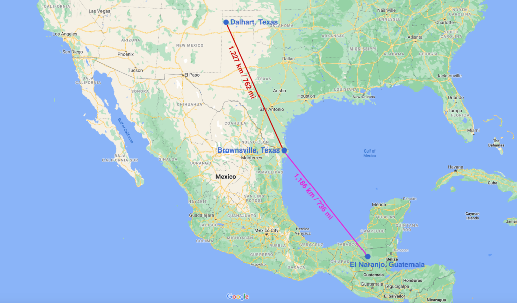
9. Brownsville, Texas is closer to El Naranjo, Guatemala than Dalhart, Texas.
Brownsville sits on the Gulf Coast across the border from Matamoros, Tamaulipas, México. It’s about as far south as you can go in Texas. Dalhart is located in the far northwest corner of the Texas Panhandle, about 75 km (45 mi) south of Boise City, Oklahoma.
Because of Mexico’s unique shape, Guatemala is actually closer to Brownsville than Dalhart is. As the crow flies, El Naranjo, Guatemala is 1,186 km (736 mi) from Brownsville, while Dalhart is 1,227 km (762 mi) from Brownsville. It’s hard to wrap your head around, but you read that right. Brownsville is closer to a town two countries away than it is to a town in the same state. There are not too many cities or towns in the world that can make that claim.
If that wasn’t enough to blow your mind about Brownsville, wrap your head around this.
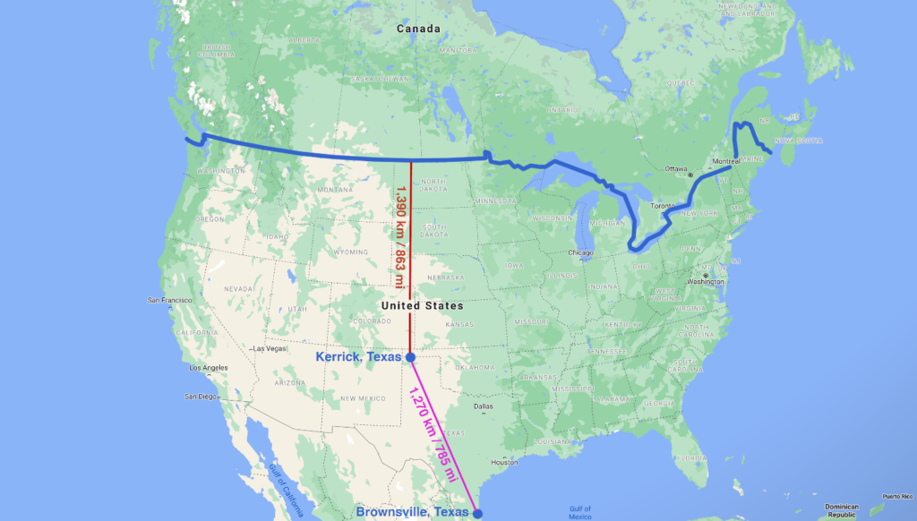
10. If you travel from Brownsville, Texas to Kerrick, Texas, you will be almost half way to Canada.
I know. There’s no way this can possibly true, right? As we said earlier, Texas is big. The small town of Kerrick sits right on the state line between the Texas and Oklahoma Panhandles. As the crow flies, you’ll travel 1,270 km (785 mi) from Brownsville to Kerrick. Once you’re in Kerrick, it’s only 1,390 km (863 mi) north to the Canadian border. You’ll cross the border into North Portal, Saskatchewan.
Conclusion
I hope that if there’s one thing you learned today, it’s that Texas is enormous and its geography is full of quirks and oddities. Because of that, it’s also an incredibly diverse place to explore. Visit swamps, beaches, farmland, prairies, canyons, mountains, and deserts without having to leave the state.
If that’s not enough, Mexico is right next door if you’re looking to dip your toe into the world of international adventuring. Alternatively, head north to Oklahoma to experience some of the best storm chasing in the world. Though I must say from experience, chasing storms in the Texas Panhandle is second to none. I hope you enjoyed our excursion into Texas geography. Stay tuned for more Weird Geography coming soon.
Top Photo: Texas Welcome Sign on Interstate 40 as you enter from Oklahoma
Benonine, Texas – August, 2017