Almost 30 years to the day after Hurricane Bob made landfall in Rhode Island, Hurricane Henri is set to be the first storm in a long time to make landfall in New England as a hurricane. If you live anywhere in New England, particularly on the south coast, you need to be taking this thing seriously and should already have begun preparations to protect your property. That being said, while it certainly can and likely will do some damage, even in the worst-case scenario Henri is not going to be the type of storm that wipes towns off the map. As we said during tornado season when I lived in Oklahoma, don’t be scared, be prepared.
Big Picture Overview
Before we jump into models, let’s look at the big picture. Here’s what the upper-level winds across the continental US look like. Henri is currently sitting in the bight between the Bahamas and Cape Hatteras.
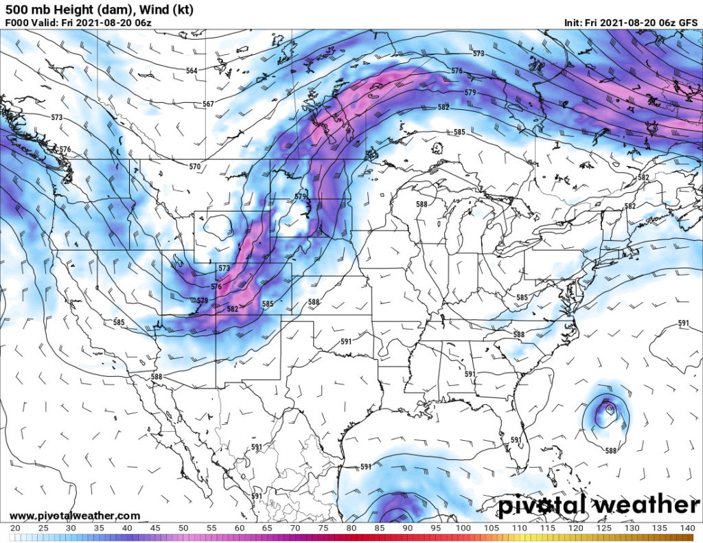
Looking at the map, there are a couple things that will impact Henri as it churns towards New England.
- A large ridge of high pressure sits over Ontario and Québec
- A mini-trough (it’s a little big to call it a shortwave) currently centered over Pittsburgh is passing through the Ohio Valley
So how will they impact Henri? Quite a bit. The high pressure system will slow Henri down as it approaches New England. The mini-trough, which is a weak area of low pressure, will pull Henri towards it. That trough is the culprit behind why the track has so drastically shifted west over the past 24 hours.
Additionally, Henri has been in a sheared environment for the past 24-36 hours. That shear has dissipated, creating very favorable conditions for Henri to strengthen as it moves north.
Current Watches and Warnings for Henri in New England
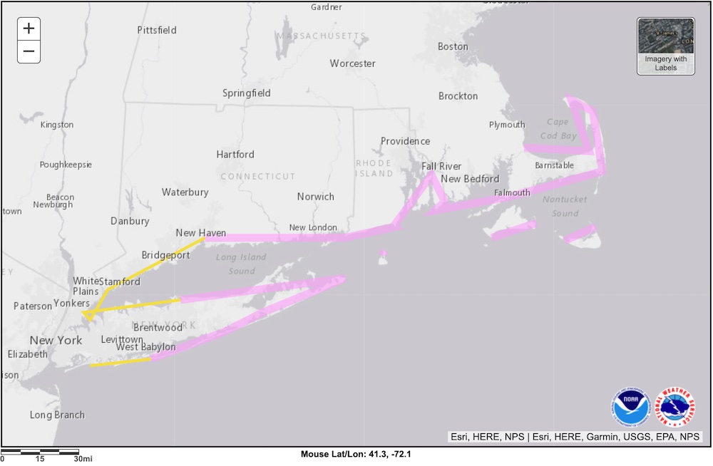
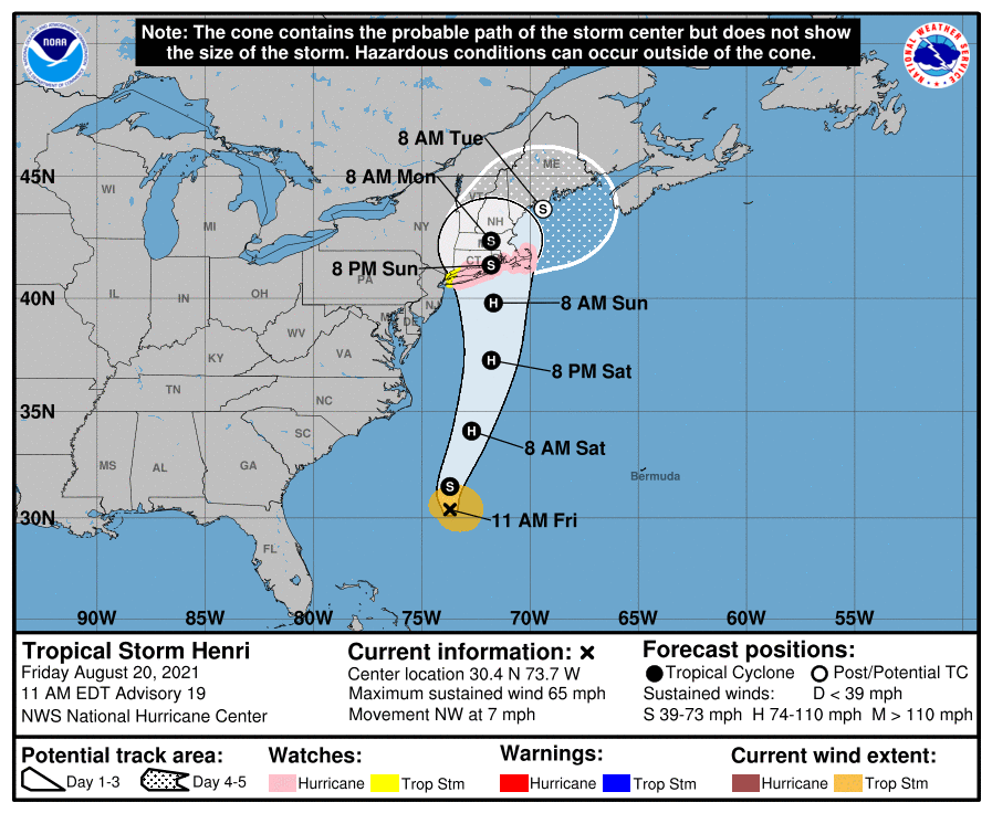
As expected, the National Hurricane Center issued Hurricane and Tropical Storm watches for southern New England and parts of New York this morning with its 5 AM EDT advisory for Henri.
Hurricane watches extend from Plymouth, MA to New Haven, CT, and include all of Cape Cod and the Islands. If you’re on Long Island, you’re under a hurricane watch if you’re east of a line from Port Jefferson to the west end of Fire Island. Tropical Storm Watches cover the rest of Long Island Sound and the south coast of Long Island. As of right now, New York City is not under any watches, but that will likely change over the next 12 to 24 hours. The same goes for Boston.
What Do The Models Predict for Henri’s Impact in New England
A good forecaster knows how to look at the models and determine which ones to give the most weight to when they make their forecast. I have my favorite collection of models I turn to when forecasting hurricanes. I want to emphasize when you look at the models, don’t focus on one particular outcome. Instead, you want to look for patterns. Where do they agree? Where do they disagree? If they disagree, why do they disagree? Are there any anomalous runs that should be immediately discounted? Models that have been consistently accurate that are in agreement are the ones you want to focus on.
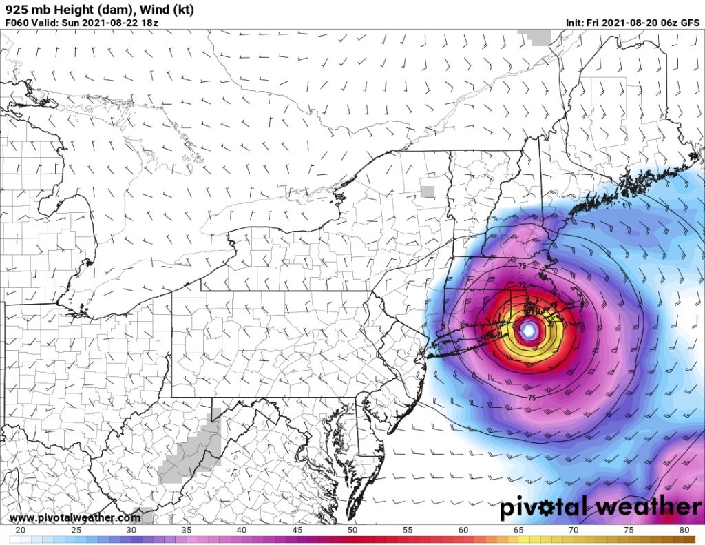
The GFS (American) Model
The GFS has been the most consistently accurate model for both Hurricane Henri as well as Hurricane Grace, which is currently heading towards a second landfall on Mexico’s Gulf Coast after passing over the Yucatán. As a result, we’ll use it as the basis of our forecast to which we can compare the other models. This morning’s runs remain consistent with yesterday’s. The GFS has Henri following a very similar path to Hurricane Bob into southern New England. It makes landfall in Narragansett Bay with wind speeds of 74 knots (85 mph).
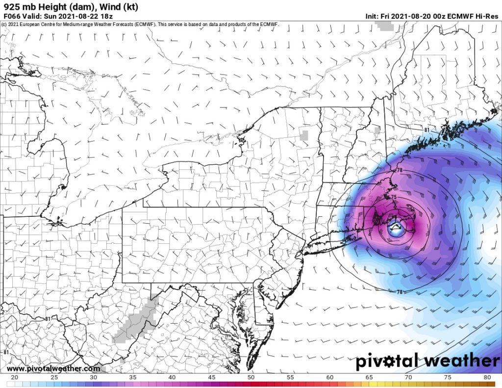
The ECMWF (European) Model
The ECMWF has been a bit of an outlier with Henri’s strength, but it has been in lockstep with the GFS for where Henri will track. While you can’t completely discount its wind speed forecast, you will notice that it is noticeably weaker than the other models. However, wind speeds in the ECMWF forecast for Henri have trended up over the past 24 hours, meaning that it will likely align with the GFS as Henri approaches New England.
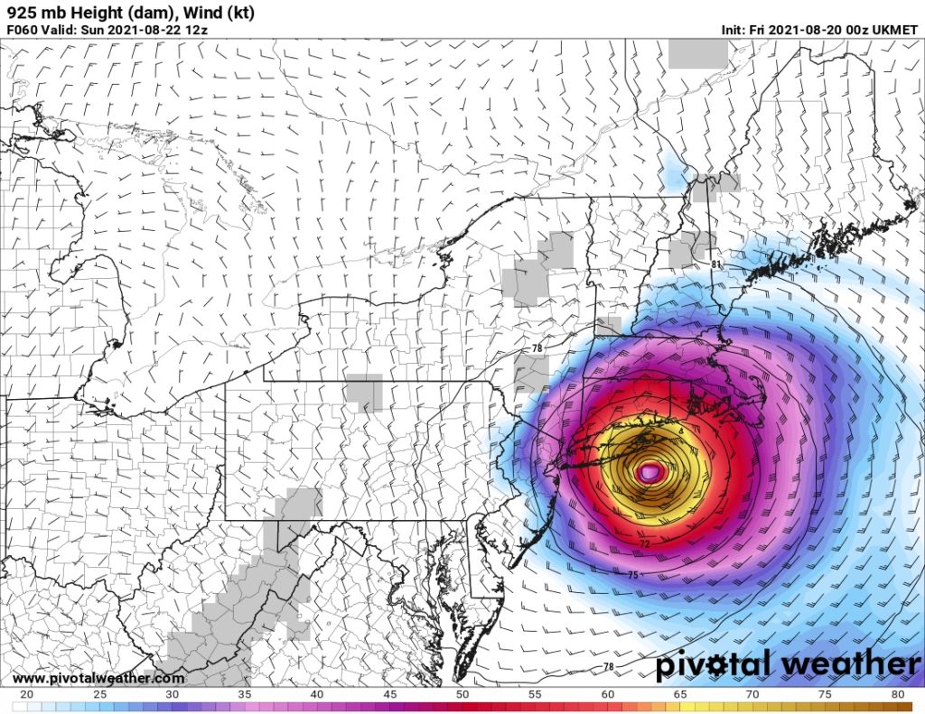
The UKMET (United Kingdom) Model
While the ECMWF was an outlier for Henri’s strength, the UKMET has done the exact opposite. Its strength forecasts are in strong agreement with the GFS, but its forecast track for Henri has trended much further west than the other models. Interestingly, the UKMET is also showing signs of coming into agreement with the GFS. In its runs just yesterday, the UKMET showed landfall possibly as far west as New Jersey. This morning’s runs have pulled it much further back to the east and closer to both the GFS and the ECMWF tracks.
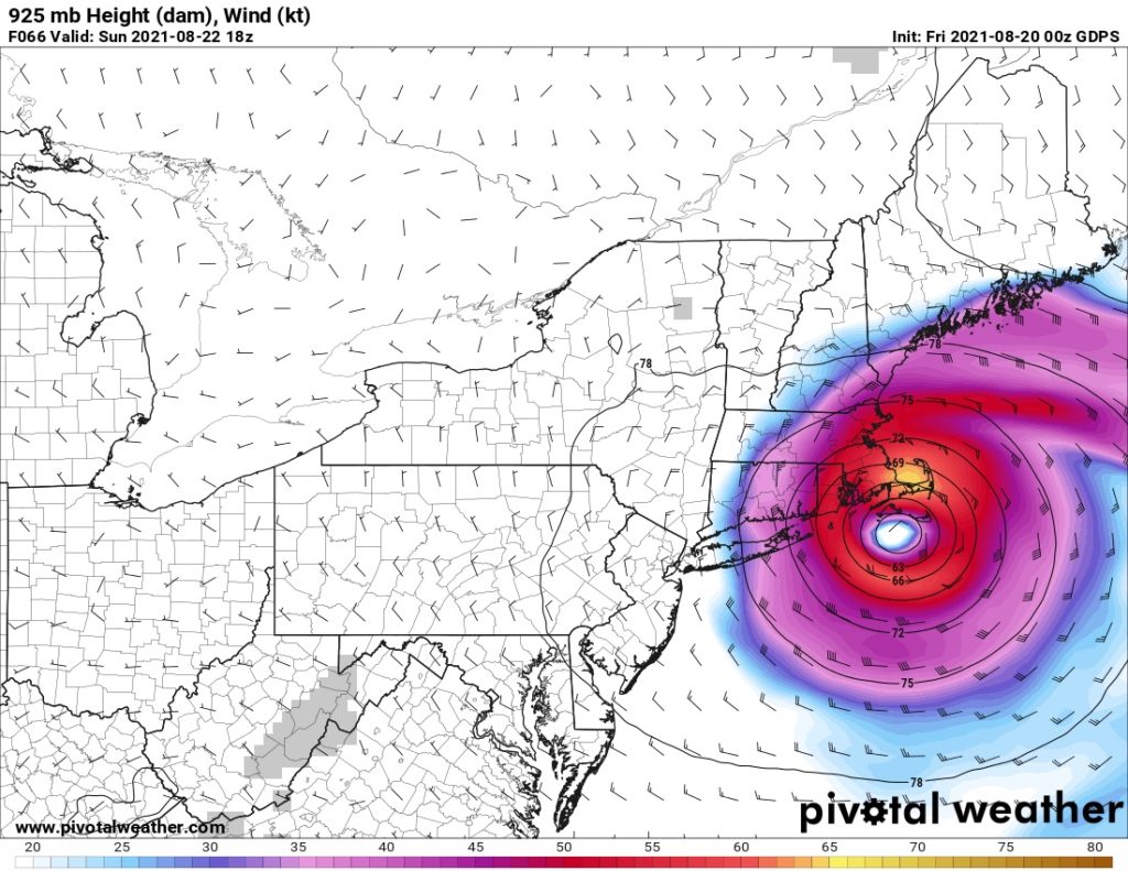
The GDPS (Canadian) Model
The GDPS has largely been in agreement with the GFS on both strength and track over the past 48 hours. From a forecasting standpoint, that’s a very good thing. It means we can give less weight to the ECMWF’s outlying strength and the UKMET’s outlying track. It also means that we should expect those outliers to align with the rest of the models that are in agreement within the next 36 hours or so.
Model Summary
Before we put our official forecast together, let’s stop and think about which models should get the most weight. Because the GFS (American) and GDPS (Canadian) are in close agreement, we’ll give the most weight to those. Additionally, the ECMWF’s track and the UKMET’s strength are also in close agreement with the other two models, so we can give them plenty of weight as well. As for the outliers, I don’t want to completely discount them because they are trending back towards the models that are all in agreement. If anything, the fact that they’re trending back only reinforces our confidence in the other models.
| Model | Max. Sustained Winds at Landfall | Makes Landfall Near |
|---|---|---|
| GFS (American) | 74 kts / 85 mph | Newport, RI |
| ECMWF (European) | 47 kts / 54 mph | Martha’s Vineyard, MA |
| UKMET (British) | 89 kts / 103 mph | The Hamptons, NY |
| GDPS (Canadian) | 65 kts / 75 mph | Martha’s Vineyard, MA |
Our Official Forecast for the Impact of Henri in New England
Based on the models we looked at, along with a little intuition and gut feelings, we can make our own official forecast. Hurricane Henri making landfall is southern New England is all but guaranteed. The big questions are where will it hit, and how strong will it be. Here are our best guesses.
| Parameter | Forecast |
|---|---|
| Time of Landfall | Sunday, 22 August, 2021 – Noon to 9 PM EDT |
| Location of Landfall | Upper Cape Cod/Martha’s Vineyard to CT/RI State Line |
| Max. Sustained Winds at Landfall | 60 to 70 knots (70 to 80 mph) |
How Does It Compare to the National Hurricane Center’s Advisory?
If we did our forecasting correctly, our forecast should be pretty similar to the National Hurricane Center’s official forecast. Indeed, the center of the National Hurricane Center’s cone of uncertainty brings Henri ashore near the Connecticut/Rhode Island State line as a strong tropical storm.
Conclusion
Henri is a potent tropical cyclone that folks in New England should take seriously. If it makes landfall as a hurricane, it will be the first hurricane to hit New England since Hurricane Bob in 1991. Whether it can actually do that remains a flip of a coin. I’ll be posting daily updates about Henri at least until it makes landfall. Please don’t hesitate to reach out if you have any questions. Be smart and stay safe.
Thank-you, Matt! I appreciate the discussion.
Thanks, Bill!
Pingback:Hurricane Henri in New England: Saturday Morning Outlook
Thanks for inbiast insight! Miss you!
Thanks, Josey! Hope all is well with you and hope to see you soon.