After a fickle 48 hours of massive track shifts across southern New England, models are finally converging on a solution as Henri trains its crosshairs square on the south coast. The westward march of Henri’s track has stopped, and this morning’s model runs have actually brought the track back to the east a bit. As I’ve said before, you shouldn’t focus on any particular model solution or exactly where the eye will make landfall. Henri is a massive storm and its impact will be felt across the entire south shore of New England, from Cape Cod to New York City.
Big Picture Overview
The primary steering currents that are driving Henri have strengthened since yesterday’s discussion. The low has set up over West Virginia and continues to dig to the south and east. Similarly, the high pressure has firmly established itself over Québec.
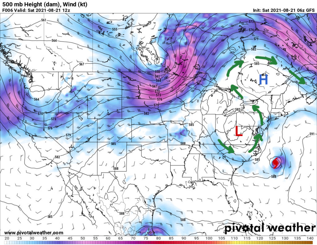
Because air moves from areas of high pressure to areas of low, the low pressure system over West Virginia will try to suck Henri into it. You can see the effect in the upper-level steering currents, which the green arrows mark in the plot above. As a result, that low has been responsible for the drastic westward shift in Henri’s forecast track over the past 48 hours or so.
Unfortunately, it’s not as simple as Henri getting sucked into the upper-level steering currents and getting flung up into Ontario. Remember that big ridge of high pressure over Québec? That acts like a roadblock, preventing Henri from moving north and northwest once it makes landfall in southern New England. Furthermore, as the low pressure expands to the south and east as it strengthens, it will actually push Henri back to the east as it tries to pull the hurricane into it.
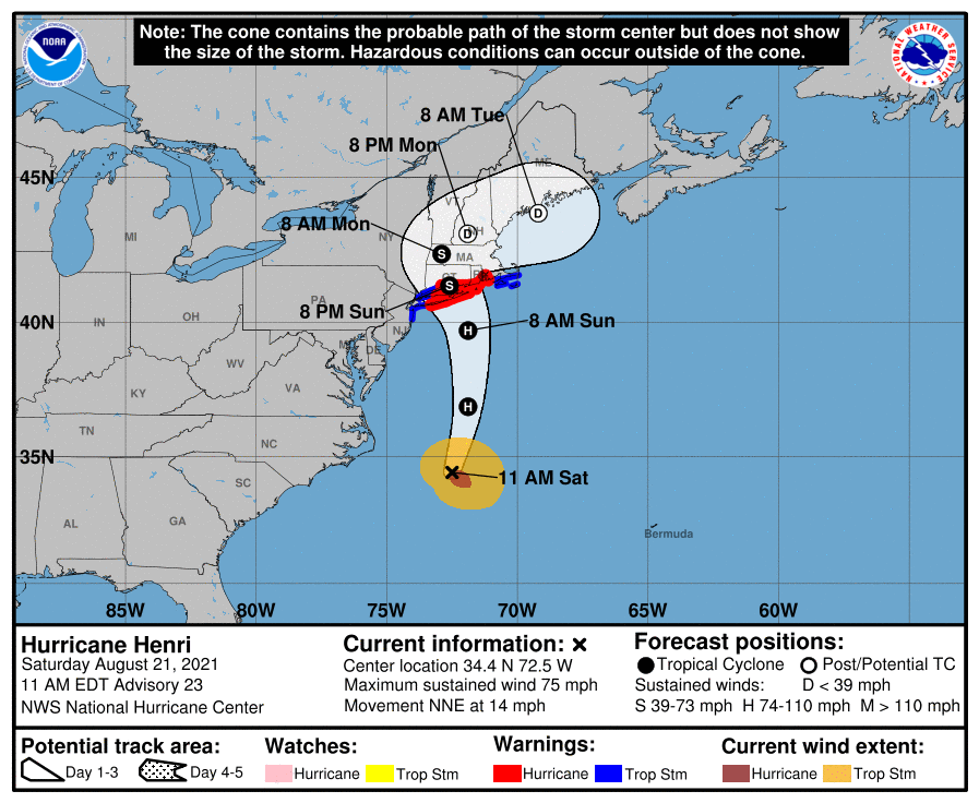
So what’s the end result? As Henri gets pulled into the low, it will screech to a halt once it hits the blocking effect from the high. As the low pressure system over West Virginia move east, it will eventually grab hold of Henri and eject it out over eastern Massachusetts and up into the Gulf of Maine. If you’ve looked at the 5 AM EDT outlook from the Hurricane Center this morning, that’s why there’s such a big kink in the track. We’ll come back to this shortly.
Current Watches and Warnings for Henri in New England
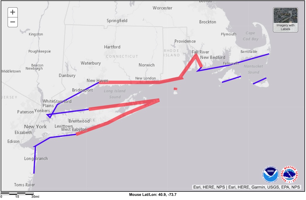
As of 11 AM EDT, Hurricane Warnings are now in effect from
- The Massachusetts/Rhode Island State Line to New Haven, CT
- Block Island
- Port Jefferson, NY to the west end of Fire Island, NY
Likewise, Tropical Storm Warnings are now in effect from
- Chatham, MA to the Massachusetts/Rhode Island State Line
- Martha’s Vineyard and Nantucket
- New Haven, CT to Port Jefferson, NY, including all of New York City
- The west end of Fire Island, NY to Point Pleasant, NJ
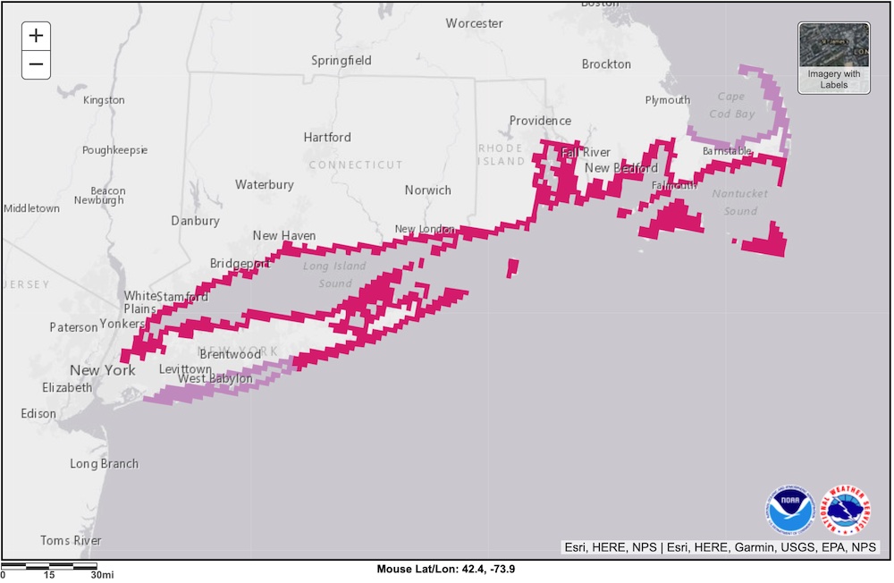
Storm Surge Warnings are also in effect for the entire south coast of New England and Long Island as Henri approaches. While the surge will not be catastrophic, it will likely flood low-lying coastal areas with 3 to 5 foot storm surge. If you live in an area that often floods, I would expect it to flood as Henri comes ashore. Please be aware there will likely be very dangerous rip currents in the warning area as well.
Model Overview
Models are finally converging on a solution after a lot of uncertainty over the past 48 hours. Remember, don’t focus on one particular outcome. Instead, you want to look for patterns. Where do they agree? Where do they disagree? If they disagree, why do they disagree? Are there any anomalous runs that should be immediately discounted? Models that have been consistently accurate that are in agreement are the ones you want to focus on.
The GFS (American) Model
The GFS has been the most stable, consistent, and accurate model over Henri’s lifecycle, so we will once again use it for the basis of our forecast. This morning’s runs remain consistent with both Friday’s and Thursday’s runs. Neither Henri’s track nor strength have changed much in the GFS runs over the past two to three days.

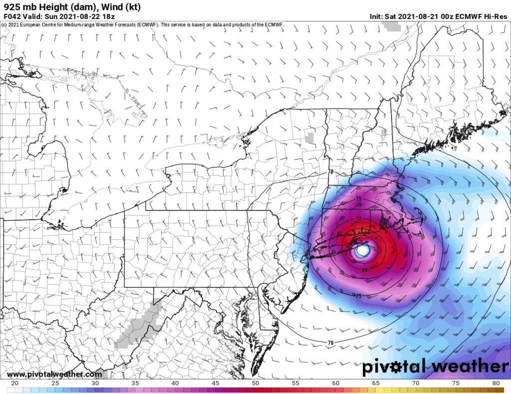
The ECMWF (European) Model
Over the past two or three days, the ECMWF’s strength forecast has been very much an outlier. This morning, it is finally coming into agreement with the other models. It still shows weaker wind speeds at landfall than any of the other models. However, because it is now in close agreement with the other models, we can give it much more weight when we make our official forecast.
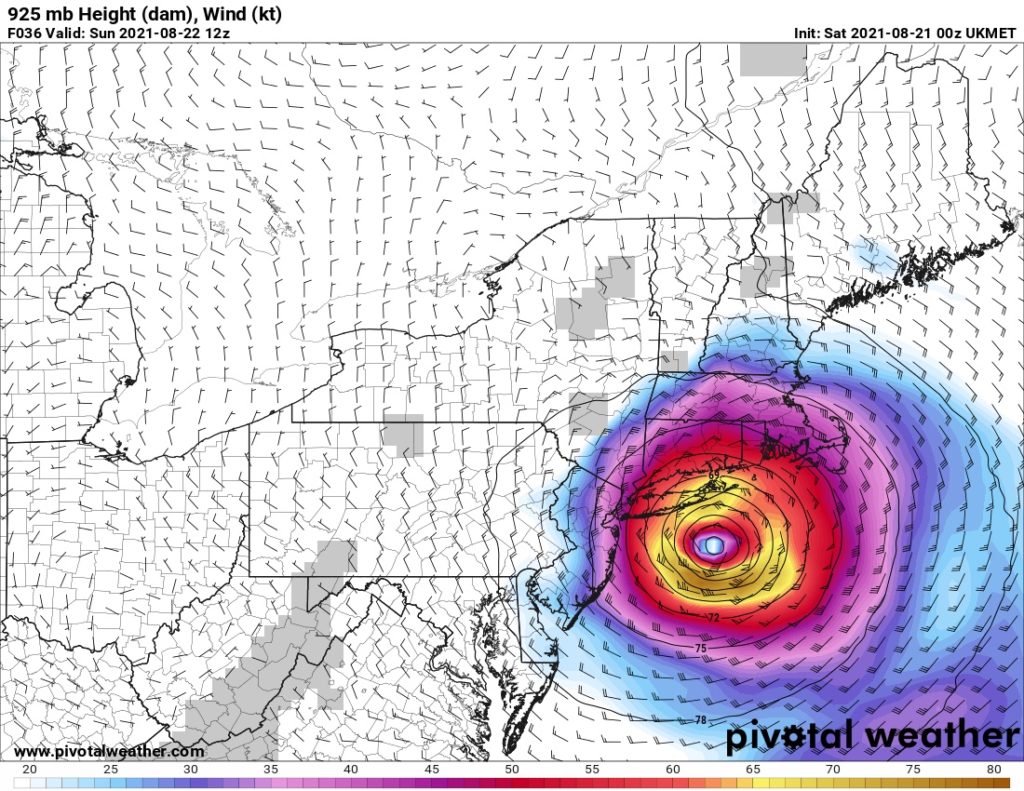
The UKMET (United Kingdom) Model
In yesterday’s model run, the track of the UKMET was quite anomalous, tracking much further west than any of the other models. As expected, that too, has largely come back into agreement with the rest of the models this morning.
It’s also worth noting that the UKMET has Henri making landfall sooner and with slightly stronger winds than any of the other models. That’s a result of the model having Henri moving faster. In the UKMET scenario, Henri spends less time over the cooler waters off the coast of New Jersey, and thus has less time to weaken. We will need to take that into account when we make our official forecast.
The GDPS (Canadian) Model
The GDPS has been in lockstep with the GFS for days. This morning, it remains that way, bringing Henri ashore at the Connecticut/Rhode Island state line. Much like the GFS, the GDPS has been very consistent, stable, and accurate over the past few days. As a result, we can use it to make forecasts with a high degree of confidence.

Despite our confidence in the model, this individual snapshot is actually a bit misleading with regards to wind speed. You may look at this map and think, oh boy, that’s in line with the weaker winds of the ECMWF. And that’s true…to a degree. All models have Henri weakening rapidly once it makes landfall on the south coast of New England. If you look at the GDPS snapshot for six hours earlier (Sunday at 8 AM EDT), winds are much stronger.

As a result, much of southern New England and Long Island will likely experience stronger winds than the 2 PM EDT snapshot indicates as the eye of Henri approaches landfall. Additionally, a small uptick in Henri’s forward speed means that it could come ashore with much stronger winds.
Model Summary for Henri in Southern New England
This morning’s model runs are in close agreement with each other. After all of the uncertainty of the past few days, it’s about as good of an agreement as we can ask for. In our official forecast, we’ll be able to give each model close to equal weight and make our forecast with a high degree of confidence.
| Model | Max. Sustained Winds at Landfall | Makes Landfall Near |
|---|---|---|
| GFS (American) | 69 kts / 79 mph | Warwick, RI |
| ECMWF (European) | 57 kts / 65 mph | Montauk, NY |
| UKMET (British) | 78 kt / 89 mph | Montauk, NY |
| GDPS (Canadian) | 60 kt / 69 mph | CT/RI State Line |
Our Official Forecast for the Impact of Henri in New England
With the models now aligning with each other, our forecast should be pretty easy to make. However, there is one parameter that I think we can discount. Based on over a decade of experience with working with mathematical models, my meteorological intuition is telling me that there is basically no way that Henri will have 90 mph winds at landfall like the UKMET says. I don’t want to discount its prediction fully, but we’ll give much less weight to it.
Additionally, because Henri is expected to weaken so rapidly once it makes landfall, the greatest coastal wind impacts will likely be felt prior to landfall. This is particularly true for areas in the eastern half of the storm…Rhode Island and southeastern Massachusetts, I’m looking at you here. Flooding will remain a threat until either Henri weakens sufficiently or it exits the area.
| Parameter | Forecast |
|---|---|
| Time of Landfall | Sunday, 22 August, 2021 – Noon to 6 PM EDT |
| Location of Landfall | CT/RI State Line to New London, CT; will likely clip far eastern Long Island |
| Max. Sustained Winds at Landfall | 60 to 70 knots (70 to 80 mph); probably a strong Tropical Storm at landfall |
Post-Landfall
Henri will continue to be pulled into the upper-level low that currently sits over West Virginia as it approaches landfall. Interestingly, the moment that the sling-shot effect (when a mid-latitude low grabs hold of a hurricane and flings it north) occurs will be at the same time as Henri runs into the road block from the strong high over Québec.
As a result, you’ll see Henri make a sharp left (westward) turn right after landfall, which is from the low trying to fling Henri up into Ontario. It will almost immediately run into the roadblock from the high over Québec and temporarily stall out over northern Connecticut and/or western Massachusetts. As the upper-level low moves east, it will push Henri east with it, eventually sling-shotting it across southern New Hampshire and eastern Massachusetts and up into the Canadian Maritimes.
The National Hurricane Center Forecast
Our forecast remains largely in agreement with the National Hurricane Center. However, from model analysis and my meteorological intuition, I believe that Henri will track slightly east of the center of the official Hurricane Center cone. While I don’t think landfall in western Rhode Island is the most likely outcome at this time, it’s certainly possible. It’s not a major difference, but it certainly could make for an interesting ride on Block Island much of the Rhode Island coast if it verifies.
Conclusion
The picture is certainly coming into focus as Henri approaches Southern New England. It remains a flip of a coin whether Henri will be a tropical storm or a hurricane when it makes landfall, but you will likely see hurricane-force wind gusts across much of southern New England. If you’re in the path of Henri, please stay safe and enjoy the ride. Please let me know if you have any questions, and stay tuned for tomorrow morning’s update.
Pingback:Hurricane Henri in New England: Sunday Morning Outlook
Thank for this enlightening look at Henri and your expertise. We are very impressed.
Thanks, Jonathan! Glad you enjoyed it.
Pingback:Hurricane Ida on the Gulf Coast: Saturday Morning Outlook