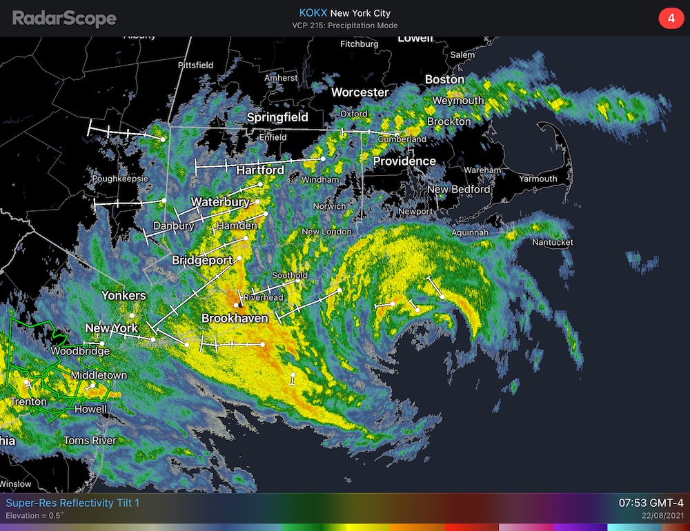
Hurricane Henri is at the doorstep and closing in on its New England target. Its effects are already being felt across all of southern New England. Unfortunately, if you haven’t begun storm prep yet, it’s too late. Conditions will continue to deteriorate across the region throughout this morning and into the early afternoon.
As expected, the upper-level steering currents have pushed Henri back to the east. It looks like the GFS (American) model was right all along. Its consistency and history of being right with Henri is why have been saying over the past three days that Henri will track east of the center of the National Hurricane Center‘s cones.
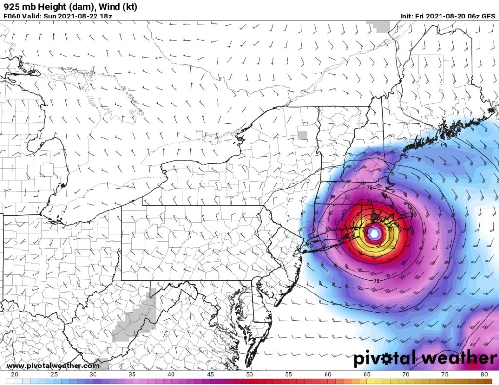
I still expect Henri to make a left hand turn while it comes ashore, as an upper-level low tries to sling shot the hurricane into Ontario. However, as we discussed yesterday, it will quickly run into a road block from a strong high pressure over Québec, briefly stalling out before being ejected across Northern New England and up into the Canadian Maritimes.
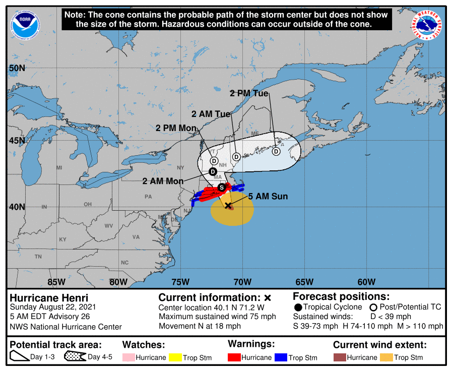
Current Watches and Warnings
The watches and warnings for Henri remain unchanged since yesterday. Hurricane Warnings remain in effect from
- The Massachusetts/Rhode Island State Line to New Haven, CT
- Block Island
- Port Jefferson, NY to the west end of Fire Island, NY
Likewise, Tropical Storm Warnings remain in effect from
- Chatham, MA to the Massachusetts/Rhode Island State Line
- Martha’s Vineyard and Nantucket
- New Haven, CT to Port Jefferson, NY, including all of New York City
- The west end of Fire Island, NY to Point Pleasant, NJ
Storm Threats and the Timing of Each
With Henri’s imminent landfall in southern New England, we are going to shift a bit from discussing exactly where the eye will come ashore to the timing of the threats Henri will bring to the region.
Wind
Because Henri is expected to weaken so rapidly as it starts interacting with the land in southern New England, most places along the south coast will likely see the strongest winds before the storm makes landfall. Even if you remove the effect of the land, Henri is over cool waters, and will be weakening as it approaches the coast.
This timing of the strongest winds is especially true for the eastern half of the storm, primarily from Narragansett Bay to Cape Cod and the Islands. Because Henri has been pushed back tot he east, those locations will likely see stronger winds than were predicted just yesterday. Wind gusts in excess of 50 knots are all but certain, except possibly for the outer portions of Cape Cod. The potential is there to see gusts to 70 knots, but it’s far from a guarantee.
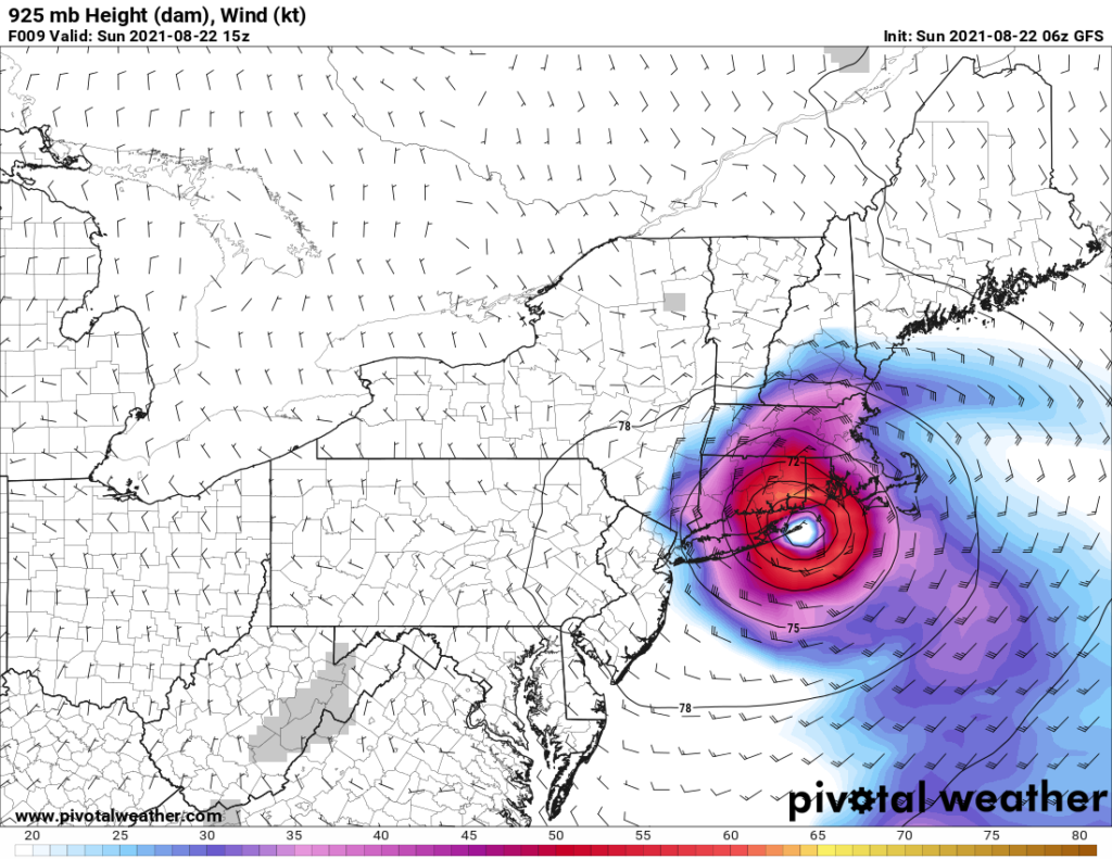
The one exception is in the area immediately around the location that the eye of Henri makes landfall. The eye is expected to pass near Block Island and the far eastern tip of Long Island before coming ashore near the Connecticut/Rhode Island state line.
Storm Surge
Because winds are out of the south (onshore) in the eastern half of the storm, Rhode Island and southeast Massachusetts will bear the brunt of the storm surge. West of Henri’s eye, winds will be out of the north (offshore), with the exception of the north coast of Long Island. However, Long Island Sound is so small compared to the open Atlantic Ocean, storm surge effects on the north shore of Long Island will be less than points further east.
To determine which locations will see the greatest impact from the storm surge, you simply need to look at where the window for the strongest winds overlaps with the timing of high tide. You’ll find the lowest impacts where the strongest winds overlap with low tide, which occurs about 6 hours before and after each high tide. Also, don’t forget that locations closer to the eye tend to see greater impacts than locations on the edge of Henri.
| Location | Window of Max. Winds | High Tide |
|---|---|---|
| Hyannis, MA | 11 AM to 1 PM | 12:56 PM |
| Woods Hole, MA | 10 AM to 2 PM | 8:27 AM |
| New Bedford, MA | 9:30 AM to 1 PM | 8:28 AM |
| Newport, RI | 8 AM to 3:30 PM | 8:21 AM |
| Westerly, RI | 9 AM to 4 PM | 9:28 AM |
| New London, CT | 8 AM to 2 PM | 9:49 AM |
| New Haven, CT | 9 AM to 1 PM | 11:48 AM |
What Does This Table Mean?
Thankfully, there is not one location that really jumps out at me as being much higher risk for storm surge. High tide in most spots in both Narragansett Bay and Buzzards Bay will fall at the beginning of that window of maximum winds, which will help limit the impact of the storm surge. Hyannis is far enough out in the outer part of Henri’s circulation that lower wind speeds will help offset the fact that high tide falls at the end of window of maximum winds. Finally, the Connecticut locations will see most likely see offshore winds. New London may see a brief period of onshore winds this morning, but they will quickly shift as Henri approaches. I would expect to see 3 to 5 foot storm surge in all of the above locations.
Inland Flooding
Based on model guidance and early radar returns, the majority of the rain is in the western Half of Henri. As a result, the highest risk for inland flooding will be in Connecticut, western Massachusetts, southeastern New York, and northern New Jersey. Depending on where Henri stalls out to make its turn to the east, southern Vermont could be at a higher risk for flooding as well. The rest of New England is by no means out of the woods, but is at much lower risk given the sharp gradient in forecast rainfall totals. Remember, if you see flooding, Turn Around, Don’t Drown!
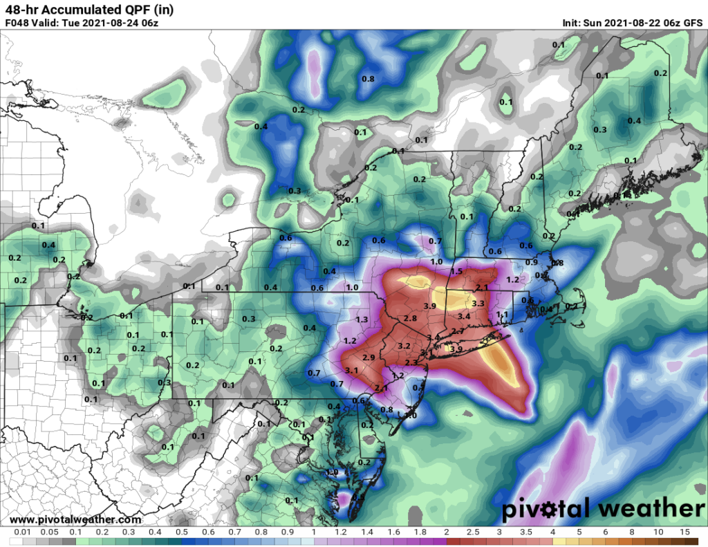
Anywhere shaded in red, yellow, or orange, is at high risk for inland flooding
Power Outages
Widespread power outages should be expected across most of Connecticut, Rhode Island, Massachusetts, and Long Island. Downed trees are the #1 cause of power outages in storms like this. New England has had a lot of rain in recent weeks. As a result, the soil is quite saturated, making it easier for Henri to uproot trees. If you see downed power lines, don’t go anywhere near them! Back away and call the electric company.
Be prepared to be without power for a while if you do lose it. We’re talking days here, not hours. But thankfully, barring any unforeseen catastrophes, it shouldn’t be weeks, either, despite some of the reports you may have heard on the news. Further north, it would not surprise me at all to see isolated power outages across parts of Vermont, New Hampshire, and southern Maine.
Conclusion
Hurricane Henri has arrived in southern New England. By now, you should be hunkered down and sheltering in place until the storm passes. Henri will likely be the most significant tropical cyclone to impact southern New England since Hurricane Bob in 1991.
Once Henri makes landfall, it will rapidly weaken. It is expected to be a tropical depression by 2 AM EDT Monday, and will be just a remnant low by midday. However, that should not be taken lightly. Just because the wind diminishes, it does not mean the threat for flooding has dissipated, too. In fact, it’s quite the opposite. Be smart, stay safe, and enjoy the ride.
Pingback:Hurricane Ida on the Gulf Coast: Saturday Morning Outlook