Less than a week after Hurricane Henri hit southern New England, we now have Hurricane Ida training its crosshairs at the Gulf Coast of the United States. This is the time of the year that the Gulf of Mexico becomes very conducive to strong hurricanes. If you’re on the Gulf Coast, you need to be paying attention to Ida. It’s not 100% set in stone yet, but it’s pretty guaranteed that Ida will be a major hurricane when it makes landfall on Sunday.
Big Picture Overview
Before we dive into the models, I always like to look at the big picture of the upper atmosphere across the United States. That way, we know where steering currents are. Additionally, we’ll also be able to know whether there’s anything in the upper atmosphere that could strengthen or weaken Ida as it churns towards the Gulf Coast.

The main thing that stands out to me on this map is the presence of what is largely zonal flow. In other words, the jet stream is fairly straight, running right along the US-Canada border. It’s a long way from the Gulf Coast, so it likely will not affect Ida the way it did Henri last weekend. Additionally, there is an area of high pressure centered over the Carolinas that is acting to steer Ida from Cuba straight up into Louisiana.
Furthermore, it means there is little to no shear over the southern United States and northern Mexico. Coupled with the very warm waters over the Gulf of Mexico, we expect Ida will rapidly intensify as it clears Cuba and the Yucatán.
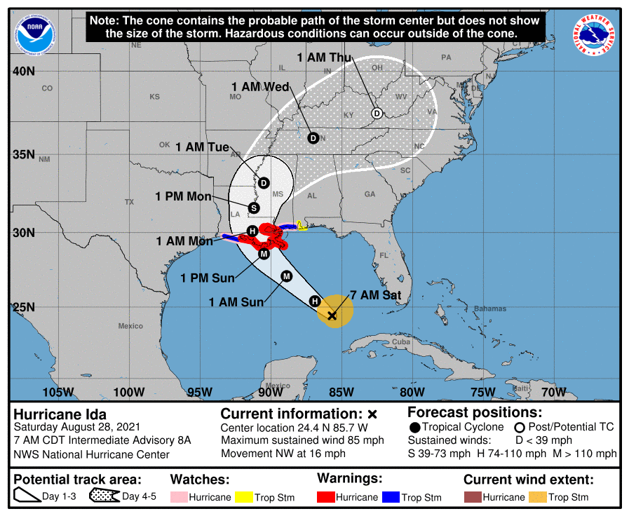
Current Watches and Warnings for Ida on the Gulf Coast
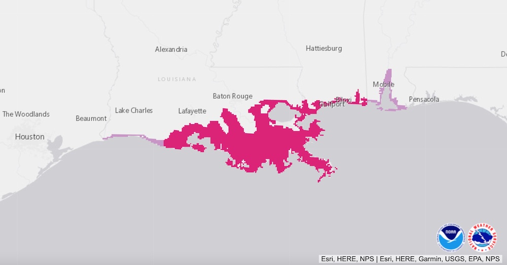
As of the 1 PM CDT advisory on Friday, Ida is officially a hurricane. Earlier in the day, the National Hurricane Center issued watches and warnings for the Gulf Coast.
Hurricane Warnings are currently in effect from:
- Vermillion Bay, Louisiana to the Mississippi/Alabama state line, including all of Lake Pontchartrain
Topical Storm Warnings are currently in effect fom
- Vermillion Bay, Louisiana to Cameron, Louisiana
- The Louisiana/Mississippi state line to the Mississippi/Alabama state line
Tropical Storm Watches are currently in effect from
- The Mississippi/Alabama state line to Orange Beach, Alabama, including all of Mobile Bay

In addition, Storm Surge Warnings are in effect from the Texas/Louisiana state line all the way to the Florida/Alabama state line. Storm surge is always a problem with Gulf of Mexico hurricanes because the water has nowhere to go but inland. On its current track, storm surge is expected to peak between 10 and 15 feet between Morgan City, LA and Lake Pontchartrain. That’s plenty high enough to cause serious flooding problems. If you live in southeastern Louisiana and are outside of the levee system, I would be getting out of there. Right now.
Model Overview
Unlike Henri, there hasn’t been much deviation in the models over the past 48 hours. They are all in lockstep with each other. As a result, we can make forecasts with a high degree of confidence. Also, please remember not to focus on one particular outcome or solution when you look at model output. Instead, look for patterns. Where do they agree? Where do they disagree? If they disagree, why do they disagree? Are there any anomalous runs that should be immediately discounted? Models that have been consistently accurate that are in agreement are the ones you want to focus on.
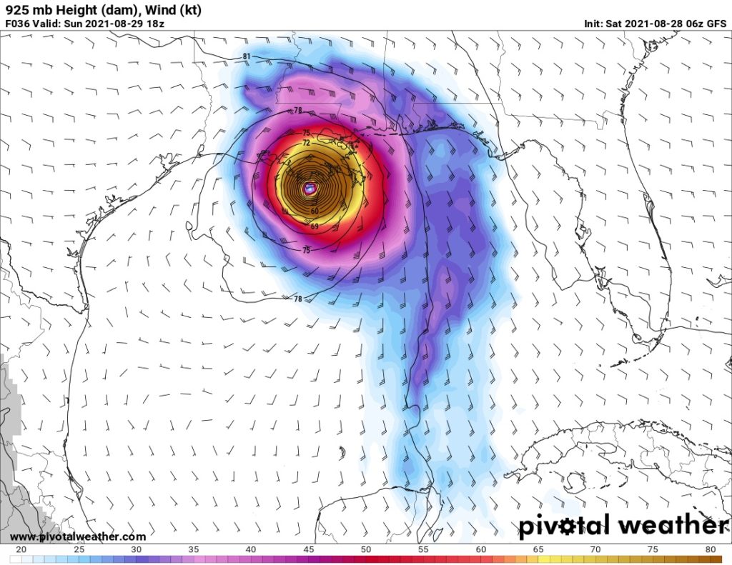
The GFS (American) Model
The GFS absolutely nailed its prediction of Hurricane Henri last weekend, unlike the other models that drifted west prior to landfall. Because it did such a good job, we’ll again use it as our basis for forecasting Ida’s approach to the Gulf coast. This morning’s GFS runs remain consistent with both Friday’s and Thursday’s runs.
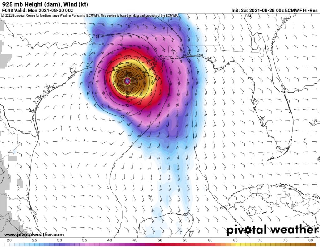
The ECMWF (European) Model
The ECMWF remains largely in agreement with the GFS for both strength and track. However, it does slow Ida down prior to landfall, bringing it ashore Sunday evening instead of midday Sunday. Thankfully, if that does verify, a lot of Ida will be over land when the slow down happens. You can’t rule out any significant additional strengthening, but it’s unlikely.
The UKMET (United Kingdom) Model
On Friday, the UKMET brings Ida noticeably further west than either the GFS or the ECMWF. Interestingly, the UKMET strongly favored a more westward track with Henri as well before coming into agreement with the other models within 24 hours of landfall. It appears to be doing the same thing with Ida. Based on its behavior with Henri, we’ll definitely need to take that into account when we make our official forecast.
The UKMET has also slightly reduced Ida’s strength at landfall, from 105 knots down to 96 knots. Keep in mind, 96 knot wind speeds still constitute a Category 3 Major Hurricane. However, I believe that the reduction in strength is a result of the shift in track back to the east. It is not due to any atmospheric conditions that would hinder strengthening. The more easterly track means the less time Ida spends over the warm, open waters of the Gulf of Mexico. Therefore, it will not be as strong when it makes landfall.

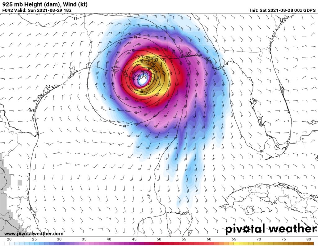
The GDPS (Canadian) Model
The GDPS really stands out as an outlier for Ida. It has Ida making landfall further east and as a much weaker storm than any of the other three models. It also predicts that Ida will be moving faster than the other models, making landfall on Sunday morning.
Interestingly, the GDPS has been very consistent with its previous runs on both Friday and Thursday. However, the track is starting to shift back to the west this morning, which closer aligns it with the other three models. This mornings GDPS runs also show stronger winds, but they’re still far less than the other three models. Coupled with how well it performed with Henri, we certainly cannot rule out its forecast, but my initial gut feeling is that we’ll have to give it less weight than the other three models.
Model Summary for Ida on the Gulf Coast
This morning’s model are all in close agreement with each other. Unlike Henri, model runs have also been very consistent over the past few days. As a result, we’ll be able to give each model close to equal weight, with the possible exception of the GDPS. We can also make our forecast with a high degree of confidence.
| Model | Max. Sustained Winds at Landfall | Makes Landfall Near |
|---|---|---|
| GFS (American) | 118 kts / 136 mph | Cocodrie/Terrebonne Bay, LA |
| ECMWF (European) | 109 kts / 125 mph | Marsh Island/Atchafalaya Bay, LA |
| UKMET (British) | 96 kts / 111 mph | Marsh Island/Atchafalaya Bay, LA |
| GDPS (Canadian) | 86 kts / 99 mph | Port Fourchon, LA |
Our Official Forecast for the Impact of Ida on the Gulf Coast
With the models largely in close agreement, we’ll weigh the GFS, ECMWF, and the UKMET essentially the same. However, I believe we can completely disregard the strength forecast of the GDPS model. I lived in Tampa, Florida for six years and watched plenty of Gulf of Mexico hurricanes over those years.
Over the past 20 years, do you know how many hurricanes have emerged in the central Gulf just north of Cuba and the Yucatán in late August and early September and did not rapidly intensify? Aside from a small handful of poorly organized tropical depressions and weak tropical storms, essentially none. That’s why I believe there is basically zero chance of Ida being a Category 1 or weak Category 2 hurricane when it hits the Gulf Coast as the GDPS says.
For the track forecast, I’m inclined to give a bit less weight to the UKMET’s westerly track, especially now that it’s shifting back to the east. Last weekend, it heavily favored a westerly track for Henri before shifting back east in the 24 hours leading up to landfall. It is doing that again with Ida.
With the cutoff for a major hurricane being 96 knots or 111 mph, we can confidently say that Ida will be a major hurricane when it slams into the Gulf Coast in Louisiana.
| Parameter | Forecast |
|---|---|
| Time of Landfall | Sunday, 29 August, 2021 – Noon to 8 PM CDT |
| Location of Landfall | Cocodrie to Atchafalaya Bay, Louisiana |
| Max. Sustained winds at Landfall | 100 to 120 kts / 115 to 139 mph |
Post Landfall
After landfall, Ida will continue to post a significant risk of both coastal and inland flooding. Parts of southeastern Louisiana could see 10 to 20 inches of rain. Further north, the highest risk of flooding remains across all of southern and central Mississippi and northern Alabama. Stream and creek flooding is also possible across much of Tennessee.
The National Hurricane Center Forecast
Because the models are so tightly in agreement, our forecast is nearly identical to the Hurricane Center’s official cone. I believe Ida will follow the center of the Hurricane Center’s cone, unlike at certain times last weekend.
Conclusion
Ida is a serious and dangerous storm. If you’re on the Gulf Coast, you need to take it seriously. Please heed all mandatory evacuations and local orders. There’s usually a reason they issue them. If you need to evacuate, you need to be getting out right now.
Ida will likely be a major hurricane when it makes landfall in Louisiana. However, one bit of solace is that Ida did pass over Cuba instead of staying over the open waters between Cuba and the Yucatán. Unfortunately, that is unlikely to weaken Ida, but instead will just delay the strengthening and intensification. Stay calm, and remember: Don’t be scared. Be prepared.