Dominating the geography of North Africa, Algeria is one of the least known and most misunderstood countries in the Arab world. Algeria’s rich history, melting pot of cultures, and expansive Sahara Desert offer more than enough to attract even the most extreme adventurers. Interestingly, we need to dive into the more bizarre and unusual side of Algeria’s geography and culture to fully understand its rich, diverse, and complex story. Let’s hit the road.
1. Algeria is the Largest African Nation and the 10th Largest Nation in the World
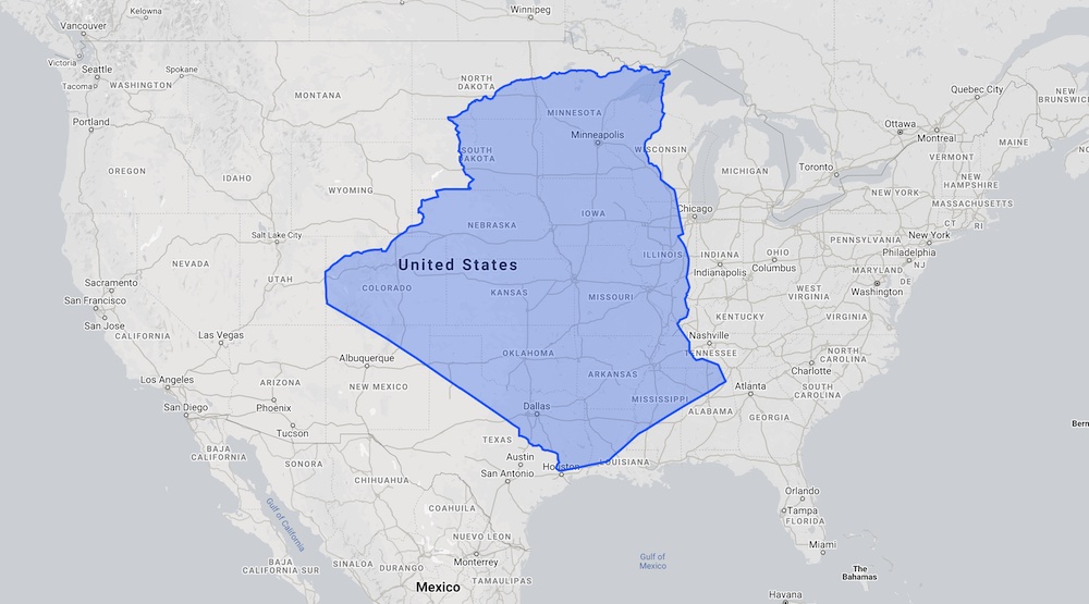
Covering a massive 2.38 million square kilometers, Algeria just barely edges out the Democratic Republic of Congo (2.34 million square kilometers) as the largest country in Africa. The difference in size between the two nations is roughly the size of the US State of Indiana.
One aspect of African history that makes it particularly fascinating is that geographies are constantly changing. Algeria has only been the largest country in Africa since 2011. Any guesses as to which country held the title prior to Algeria? I’ll give you a hint: it’s a country that still exists today.
Prior to 2011, Sudan was the largest country in Africa, checking in at 2.51 million square kilometers. On 9 July, 2011, South Sudan broke off from Sudan and became its own country. As a result, the ensuing reduction in size dropped Sudan from the ninth to the sixteenth largest country in the world. But that’s a story for another day.
So just how big is Algeria? If you overlay it on a map of the United States, it covers the middle third of America almost perfectly.
Now, despite it being the largest country in Africa…
2. Only 12% of the Country’s Land Mass is Inhabited
The Sahara Desert covers the vast majority of Algeria. It’s one of the most extreme environments on the planet. Temperatures in the Sahara can reach 55°C (131°F), and going three or four years between rainfalls is quite common.
Nonetheless, Algerians haven’t let that fact stand in their way. Only 3% of Algeria’s land mass is cultivated, but that’s enough to feed their population self-sufficiently. Less than 1% of Algeria is forest.
So just how inhospitable and uninhabitable is the Sahara? We can explain it with simple math. The Sahara covers 88% of Algeria. What’s 100% minus 88%? 12%. And how much of Algeria’s land mass is inhabited? Yes, that Sahara really is that extreme and inhospitable.
3. Algeria is Home to Some of the World’s Largest Sand Dunes
Aptly named the Isaouane-n-Tifernine Sand Sea, the dunes in eastern Algeria are the largest in Africa. The dunes cover an area roughly the size of Kentucky and stretch into neighboring Libya. They tower up to 465 meters (1,525 feet) above the desert floor, reaching elevations of 2,000 meters (6,000 feet) above sea level. If you thought tromping through soft sand was tough, try doing it at elevation.
As for the tallest sand dunes in the world? It surprises a lot of people, but the top 3 tallest sand dunes are all in South America. Reaching elevations of nearly 3,000 meters (10,000 feet) above sea level, you can find them in Argentina, Peru, and Chile respectively.
4. Algeria was Once Part of France and Remains Rich with French Culture to this Day
Like much of West Africa, Algeria fell to French colonization efforts in the 19th century. The French occupation of Algeria began when they landed in Algiers in 1830. The French conquest of Algeria was bloody and brutal, killing untold members of Algeria’s indigenous population.
“[The French] had been for over a hundred years in Algeria and were determined that it was part of France, and they damn well were going to stay there. Of course, there was a very strong school of thought in the rest of Africa that they damn well weren’t.”
Joseph C. Satterthwaite, US Assistant Secretary for African Affairs, in 1961
While their relations were never great, the relationship between France and Algeria improved in the early 20th century. In 1961, the Algerian people voted overwhelmingly (about 80%) for independence from France. Following several failed coup attempts, French leader Charles de Gaulle formally recognized Algeria’s independence in 1962. Algeria’s relationship with France has remained close since then, but there have been difficult times.
130 Years of French Occupation Leaves Its Mark on Algerian Culture
Walk through any city or town in northern Algeria and you’ll find a melting pot of cultural influences dating back over 2,000 years. However, you’ll find French influences to be the strongest simply because they have been the most recent power to occupy Algeria. You’ll find plenty of French food, art, literature, and more. Over the years, Algeria has also been a part of Spain, Italy, and Turkey, so be sure to keep a look out for those influences as well.
While not one of Algeria’s official languages, French is widely spoken throughout the country. The French language is used in Algeria much in the same manner that Spanish is used in the United States. Road signs are all bilingual in both Arabic and French. The same goes for billboards, newspapers, menus, and pretty much anything else that’s in written form.
Why is French Not One of Algeria’s Official Languages?
If you travel south across West Africa, from Sénégal down to the Congo, you’ll find that many of France’s former colonies still not only speak French, but use it as their official language. Algeria is one notable exception. Its neighbor Tunisia is the other.
So why did these two neighbors not adopt French as their official language? It boils down to two reasons.
First, the Arabs first colonized Algeria in the 8th Century as they sought fertile lands on the Mediterranean shores to grow their crops. When the Arabs came, they brought Islam with them. As a result, Algeria has been an Islamic Nation for over 1,200 years.
The Arabic language is critically important to Islam. Muslims believe that Arabic was chosen by Allah, and that the holy scripture (the Quran) shall be written entirely in, and only in Arabic. Therefore, in order to fully understand the word of Allah, all Muslims must learn to read and speak Arabic. Modern linguistic scholars have revealed that the Quran is written is such precise Arabic, that it is nearly impossible to translate it into other languages without losing any meaning.
Most Islamic nations have carried this belief into their system of government. Indeed, have a look around the nations of the Muslim world. You’ll notice they all have one thing in common. They all use only one official language: Arabic.
Second, the French occupation of Algeria was such a dark period in its history. Untold numbers of Algerians died as a result of French colonization. You really can’t fault them for wanting to distance themselves from that.
5. Algeria is a Land of Temperature Extremes…But It’s Got Nothing on Russia and Canada
It’s no secret that desert environments can be extreme, especially when it comes to wild temperature swings. Just have a look at Algeria’s all-time temperature records.
| Record Type | Temperature | Date |
|---|---|---|
| Hottest | 51.3°C / 124.3°F | 5 July, 2018 |
| Coldest | -13.8°C / 7.2°F | 2 September, 1979 |
The concept of temperature records in Algeria is actually hotly contested. If you do a quick Google search for Algeria’s all-time record high temperature, you’ll find a surprising range of claims. It turns out that weather data has not always been reliably measured or recorded, so records are broken into two categories: the hottest temperature ever reliably measured and the hottest temperature ever recorded. You’ll find numerous claims of air temperatures between 60°C and 65°C (140°F to 150°F) in Algeria. However, meteorologists have debunked those claims time and time again.
Russia and Canada put Algeria’s Temperature Range to Shame
For being in such a temperate climate, Algeria has an impressive temperature range. There’s no doubt about it. But unfortunately, Algeria doesn’t get cold enough to compete with the true champions of the temperature range. For that, you’ll need to turn to two countries that are well-known for their brutal, bone-chilling winters: Russia and Canada.
| Country | Record Low | Record High | Temperature Range |
|---|---|---|---|
| Algeria | -13.8°C / 7.2°F | 51.3°C / 124.3°F | 65.1°C / 117.1°F |
| Russia | -67.7°C / -89.9°F | 38°C / 100°F | 105.7°C / 189.9°F |
| Canada | -63°C / -81.4°F | 49.6°C / 121.3°F | 112.6°C / 202.7°F |
6. The Rarest and Most Elusive Carnivore in the World Lives in Algeria
The Northwest African Cheetah, also known as the Saharan Cheetah, is a critically endangered species native to the Sahara Desert. As of 2008, there were estimated to only be at most 250 of them left on Earth. In March, 2020, the Office National du Parc Culturel de l’Ahaggar captured footage of the first Saharan Cheetah to be seen in over 10 years. A game camera recorded the cheetah inside of Parc Culturel de l’Ahaggar (Ahaggar Cultural Park) in southern Algeria.
7. The World’s Most Dangerous and Deadly Road Runs Across Algeria
Algeria is widely regarded as one of the safest and most stable countries in the Arab world. So how did it wind up with the world’s most dangerous and deadly road? Your mind is probably drawn to the images of extremist insurgent groups traversing war-torn countries like Iraq, Afghanistan, or Yemen. But those groups are non-existent in Algeria.
The road’s danger and deadliness is not attributed to the people on it. On the contrary, it’s the lack of people on it. The Trans-Sahara Highway stretches for 4,500 km (2,800 mi) from Algiers, Algeria to Lagos, Nigeria. For reference, if you flew from Boston, Massachusetts to Bogotá, Colombia, you would have traveled 4,200 km. Running through the guts of the Sahara desert, it’s one of the truest and most extreme adventures in Africa that attracts only the bravest and most foolhardy.
Successfully completing the journey requires a lot of skill, and a little luck. The Trans-Sahara Highway is one of the most difficult passages on the planet. You’ll need a specially outfitted 4×4 and plenty of desert experience to survive the extreme and harsh environment. Even though 85% of the route is paved, much of the pavement is littered with potholes and in disrepair. In addition, daytime temperatures often hit 50°C (122°F) and sandstorms bury the highway under massive drifts of sand on a regular basis. There are no services or supplies along the route. If you break down or have a medical emergency, you’re on your own. You better know how to fix it or treat it. And then there’s all of the bureaucracy you have to deal with if you want to cross any of the international borders along the route.
So what attracts so many adventurers to the Trans-Sahara Highway? The opportunity to experience the Sahara at its most mesmerizing. You’ll get to see something that very few others have, in its rawest and most pristine form.
8. Despite Being Almost Entirely Desert, Algeria is Full of Marine Fossils
From a climatological standpoint, the Sahara is absolutely fascinating. In some of its most uninhabitable locations, archaeologists have found fossils of tropical jungle plants, mangroves, fish, and even whales. Furthermore, they have uncovered evidence of ponds, lakes, and oceans in the middle of the Sahara.
How does all of this marine evidence wind up in the middle of the world’s largest desert? If we look at what archaeologists have uncovered in the Sahara, it’s clear that it hasn’t always been a vast desert.
Every 20,000 years, there is a wobble in the Earth’s orbit that causes a dramatic shift in the tropical monsoon over Central Africa. Depending on the direction of the orbit, the monsoon either shifts north, over the Sahara, or shifts south, over equatorial Africa. As a result, the Sahara cycles back and forth between a “Desert Sahara” and a “Green Sahara”.
Uncovering Evidence of a Green Sahara
The first step to confirming the existence of a Green Sahara is to look at the deposits of Saharan dust in core samples taken in the Atlantic Ocean off the west coast of Africa, as well as in both North and South America. In those core samples, there is a significant reduction in dust deposits every 20,000 years. During the Green Sahara, trees, vegetation, and water hold the soil in place, preventing the massive sand storms that are common during the Desert Sahara.
Furthermore, archaeologists have also found paintings and sculptures depicting the Green Sahara in places no civilization would survive today. Coupled with the marine fossils found in the Sahara, we can paint a pretty clear mental picture of what the Green Sahara looked like.
What Does the Green Sahara Look Like?
Because the Sahara covers such a vast area, the Green Sahara is diverse. You’ll find swamps that resemble the Florida Everglades, and dense jungles like you’d find in South America or Southeast Asia. There will also be lush savannah and grasslands that closely resemble the ones you find in Kenya or Tanzania.
But most important for the survival of civilizations is the presence of water. The Green Sahara was covered in ponds and lakes. Some lakes were likely the size of the Great Lakes, if not bigger. There was more than enough water in the Green Sahara to support human, plant, and animal life.
When Is the Next Transition to the Green Sahara?
The most recent transition from the Green Sahara to the current Desert Sahara occurred about 5,500 years ago. The drying of the Sahara as it underwent that transition forced people living in what is currently Egypt to abandon their homes and re-settle along the Nile River. This migration gave rise to cities that eventually became the Ancient Egyptian Civilization.
The next transition back to the Green Sahara is still about 15,000 years away. Once the African monsoon shifts, it takes between 100 and 200 years to complete the transition. To put that into perspective, if the transition had started during the American Civil War in the 1860’s, it would be just barely complete today.
9. Algerian Cherries and Dates are Widely Renowned as the Best in the World
Thanks to its moderate, but diverse climates along its northern Mediterranean coast, Algeria is world-famous for its cherries and dates. And they’re not just great. They’re widely considered to be the best in the world. Don’t forget that at its closest point, Algeria is only about 220 km (135 mi) from Italy and 150 km (90 mi) from Spain, and we all know how good the fruits and veggies from both of those countries are.
10. Algerian Vexillology Tells a Fascinating Story of the Country’s History
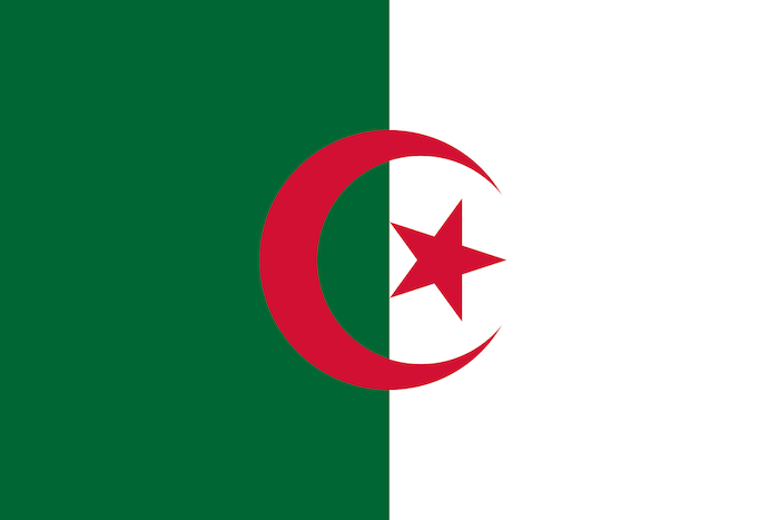
The Algerian flag is very simple, but tells a fascinating story of the country’s history, going back at least 1,200 years. Designed when Algeria gained its independence from France in 1962, the flag is nothing more than a red star and crescent on a field that’s half green and half white. But its symbolism stretches far deeper than that.
- The green field is a symbol of Islam. The flags of most Middle Eastern and Islamic Nations nations have green on them.
- White symbolizes peace and purity.
- The star and crescent emblem can be traced back when the Ottoman Empire ruled Algeria prior to the French colonization. It’s also a symbol of Islam. You can find a very similar symbol of the flag of Turkey, which is where the Ottoman Empire originated.
- The red color actually has two meanings. It symbolizes the blood that the Algerian people shed during the war of independence from France. It’s also another link to the Ottoman Empire, which used the same flag Turkey does today. The Turkish flag is red with a white star and crescent on it.
And on a side note, a big shout out to The Big Bang Theory for introducing me to the term “vexillology” back in the day.
Bonus: A Few Extra Facts
Because Algeria is such a fascinating country, here are a few bonus bizarre facts.
- Algeria was called Numidia in ancient times. The name comes from a people who were well known for their horse-drawn army. Numidians later came to be known as Berbers. Today, Berber is one of the national languages of Algeria.
- It’s the largest oat market in Africa, and one of the largest producers of artichokes and watermelons in the world.
- Despite the fact that French is not an official language, Algeria is currently the second-largest French-speaking community in the world. Over 2/3 of the population can speak French, mostly as a second language. In 2016, 68% of Algerians that used Facebook posted in French.
- The furthest capital from Algiers (as the crow flies) is Wellington, New Zealand, which sits a whopping 19,141 km (11,894 mi) away
Conclusion
We’ve only begun to scratch the surface of Algeria’s history and culture. One of the aspects I love about writing this Weird Geography series is just how much I learn about these countries as I research them. This was especially true for Algeria because my studies of French culture did not cover Algeria at all. As a result, the whole melting pot of cultures along the north coast of Africa has been giving me that “tug” for quite a while now. Whether you’re interested in Algeria’s history, culture, or climate, it offers something for everyone. Where will your next adventure take you?
Top Photo: Hikers Cross Seemingly Endless Sand Dunes
Death Valley National Park, California – February, 2020